Wrangell Lay Day: Totems, Tuna, and a Land-Based Recon

Heritage Harbor might be outside of town, but getting to downtown Wrangell is a breeze—especially by dinghy. The 4-hour yellow loading zone at the base of the harbormaster’s ramp is ideal for tying up. Still, today I (Bob) decided to scout out the walking route for those days when the Strait’s too sloppy for a smooth dinghy ride.

The verdict? From Heritage Harbor to the City Market and Sentry Hardware & Marine, it’s a 1.2-mile walk—flat, easy, mostly sidewalked, and clocked at 40 minutes at my usual “trudge” pace. Not bad at all.

view of the harbor from the walk from heritage harbor to town.

on of the many sights along the route to town

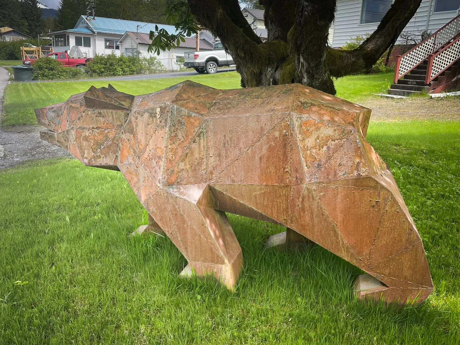
interesting yard art in wrangell

For lunch, we tried Michelle’s Taste of Asia on Front Street. Normally we might have passed it by, but Sylvia from Alaska Vistas gave it such a rave review yesterday that we had to check it out. She was right—the spicy tuna sushi rolls were outstanding, and the post-lunch ice cream cone didn’t hurt either. We swung by afterward to thank her, and Karen even recruited some curious Nat Geo cruisers to go try it for themselves.

yummy lunch at Michelle’s Taste of Asia

A fun discovery today was the Carvers Shed, a working totem studio open to the public. Here, master carvers recreate aging or damaged poles—an effort to preserve heritage before these cultural icons return to nature, as is traditional. We chatted with a couple of the carvers and came away with a deeper appreciation of the stories these poles carry.

driftwood moose in wrangel

Just a short stroll away is the Nolan Center, a museum and visitor hub that’s always worth a look. We also made another attempt to visit the longhouse on Kah Shakes Island, but no luck—skunked again!

Kah Shakes longhouse, been here many times, but it is never open when we arrive

on the way to Kah Shakes Island you pass the harbors tidle grid, one of the largest i’ve seen

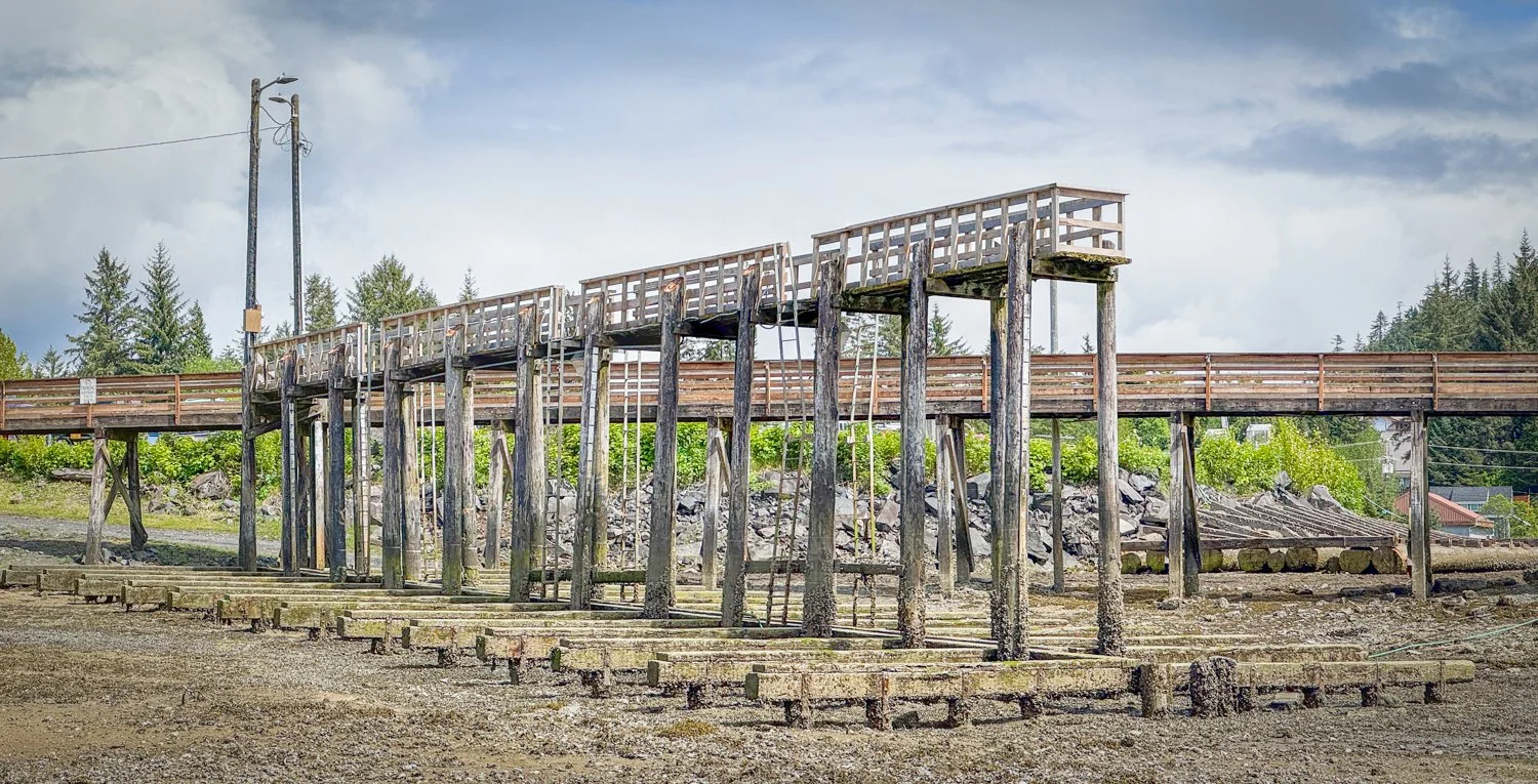
wrangel tidel grid, a double sided behomouth

Back at Heritage Harbor, we connected with some boaters just a few slips down—friends of friends from Navigator, both cruising Krogen 48s. They keep their boats in Wrangell year-round and had great insight into local logistics. It was a timely and fascinating chat, especially since we’ve been toying with the idea of overwintering here instead of making the long haul back to Bellingham.

A slower day? Sure. But packed with discoveries, good eats, and even better conversation—everything a lay day should be.

Berg Bay to Wrangell: Burgers, Deadheads, and the Downpour

After a picture-perfect day exploring Berg Bay, we pointed OceanFlyer toward Wrangell. With calm seas, a helpful current, and even a few sun breaks, the three-hour cruise felt like a reward.

sunrise in berg bay

The harbormaster directed us to Heritage Harbor, just outside town. We’d been here before—two long side-tie docks for transients—but this time the fishing fleet was still in force. Luckily, we found a prime spot on T1 with 50-amp power... eventually. The first power box was dead, so we called for a harbor staff encore. They couldn’t have been nicer and got us hooked up in no time.

Town is a quick dinghy ride across Zimovia Strait. Seas were glassy, the sun still hanging on, and we tied up in the yellow loading zone at Reliance Harbor as instructed.

Unfortunately, Wrangell was in low gear. The Thirsty Beaver—our dinner target—was closed for renovations. Nic’s was also dark despite what the posted hours said. But fortune smiled at the Wolf Shack, where we devoured sweet & spicy burgers on their front porch—unexpected and excellent.

lunch at the wolf shack

Wandering through town, it seemed nearly every shop was closed until Sylvia, the ever-enthusiastic owner of Alaska Vistas, popped out of her storefront like a ray of sunshine (just as the real sun gave up). A marine biologist, captain, and seasoned fish boat hand, she gave us the inside scoop: the closures were temporary. The Beaver and Marine Bar were being remodeled during the one window when all the contractors were free, and the Nic’s crew? Off at a Grateful Dead concert. Go figure.

As rain began to fall, Karen smugly zipped up her rain gear. I, of course, had left mine behind. By the time we picked up a few groceries at City Market and returned to OceanFlyer, I was soaked and she was smugger.

Dinner was quiet, cozy, and dry—just the way we like it after a day of surprises.

Bradfield Canal to Berg Bay: Alpine Anchorages & Creekside Adventure

We woke to low clouds and quiet in Bradfield Canal. Karen took the helm while I got a jump on dinner, prepping a chicken and penne pasta salad—always a win on days when energy runs low but appetites run high.

The cruise to Berg Bay, just south of Wrangell, was smooth and uneventful. This anchorage is a gem—narrow, deep, and tucked into alpine scenery with a Forest Service cabin at its head. The wind and current tend to hold you mid-channel. We dropped anchor in 66 feet (at high tide) and eased out 200 feet of chain.

Oceanflyer looking back to the entrance to berg bay

you can get a peak at aaron creek over the trees at the back of berg inlet

Our timing was driven by a mission: dinghy exploring up Aaron Creek at the evening high tide (+12.64 feet around 7 p.m.). With time to spare, we zipped ashore to check out the cabin and boardwalk. The sun even made a brief appearance.

The cabin, perfectly perched with a front porch view over the bay, was unoccupied—giving us a peek inside. A rope swing for kids hung from a nearby tree, and the setting felt like something out of a wilderness postcard.

We followed the well-maintained 0.4-mile boardwalk behind the cabin into a marshy alpine basin ringed by mountains. Then it was back to the boat to wait on the tide.

The cabin at Berg Bay sits at the head

OceanFlayer and her dinghy from the cabin

Well maintain boardwalk at Berg Bay

Around 5:30, we headed for Aaron Creek. The real adventure was navigating the shallow delta at its mouth. We tried the eastern branch first—until we bumped into just a foot of water. Doubling back, we found better luck on the western channel, which held 5+ feet of depth until a large sandbank halted our progress.

The payoff? Absolute serenity. A winding estuary, framed by snow-capped peaks and lush, grassy banks. Classic bear country—but no sightings today, only rainbows.

the little dot in the lower Right corner is us anchored in the west branch of AAron Creek

looking straight down you can see the shallowing water that stopped our progress.

These are the anchorages we love best: solitude, scenery, and an off-the-boat adventure waiting around the corner.

Canoe Passage to Bradfield Canal

This morning, Canoe Passage reminded us that charts don’t always tell the whole story. One island is misplotted, and on paper, it looks like the passage shoals out entirely. But as I stepped out of the shower, a 50-foot fishboat zipped past heading south. Apparently, local knowledge beats NOAA again.

The charts givethe impression it is not passable, but the local fisherman use it at high tide.

With calm weather and the generator humming, I jumped into meal-prep mode—filling the galley with the smells of future dinners while we made water.

Our destination today was new territory: deep inside Bradfield Canal, far beyond the better-known Anan Creek Wildlife Observatory. Karen had discovered a note from a past cruiser who’d made it up the Eagle River by dinghy on a high tide. That was all the encouragement we needed.

Bradfield didn’t disappoint—snowcapped peaks framed the quiet fjord as we cruised in. We passed one lone pleasure boat heading out, then had the whole place to ourselves. We anchored just west of a small lagoon near the Eagle River delta. At low tide, we could see the sandy flats and a few lurking hazards, but the water was deep and the anchor held strong.

oceanflyer flyer anchored off the lagoon entrance

lagoon on the left, eagle river on the right

lagoon entrance at low tide

eagle river entrance at low tide

looking back into Bradfield Canel with the lagoon entrance in the foreground

With the tide on the rise (+13'), we launched the drone for a better look at the lagoon and river entrances. Both looked promising.

We dinghied into the lagoon first, using Garmin/Navionics to guide us in. It was narrow but manageable and worth the effort—a peaceful pocket of calm and classic Alaskan charm.

Then came the Eagle River. Unsure how far we’d get, we followed the channel upriver—hugging the west side near a small island—until we finally ran out of depth. Surrounded by emerald grass, rolling hills, and the whisper of unseen bears, we savored the solitude.

The Eagle River off of bradfiels canal

By evening, we were back aboard OceanFlyer, tucked into the wilderness, completely alone and utterly content.

evening settles upon Bradfield canal

Meyers Chuck to Canoe Passage

Armed with our Alaska fishing permits and big hopes for spot shrimp, we set out for a pair of "secret" prawn spots just outside Canoe Passage—tips from friends who swore by them.

overview of meyer’s chuck

good look at the dock layout at meyer’s chuck

the view toward clarence strait

the back bay on theleft is lined with houses and a few provate docks

not to be used for navigation. color enhanced image showing the rocks and green mark at the entrance to meyer’s chuck

The weather flirted with us all day: the clouds occasionally cracked just enough to tease sunshine before tossing down another cold shower. Classic early-season Alaska.

Ernest Sound treated us to smooth seas, and the scenery was pure postcard—until we spotted the commercial prawners. The season opened two days ago, and the pros were already hard at work, strings of pots blanketing both of our targeted drop zones near Fisherman’s Chuck. We could’ve set ours too… if we wanted to sit on top of it all day. We didn’t. This wasn’t a prawn standoff we felt like joining—especially in 49-degree drizzle—so we kept cruising toward Canoe Passage.

Alaska has a way of making you feel small. Charts suggest tight inlets and narrow cuts, but when you arrive, they’re wide enough for a cruise ship. Canoe Passage was no different—majestic cliffs, sweeping bends, and deep, green solitude.

We dropped the hook in 40 feet near a rushing stream and watched a blacktail deer amble along the shoreline. A few sunny flickers broke through the gloom, but not enough to tempt us off the boat—except for a quick spin with the drone.

the small creek provided a pleasant serenade

looking north at the entrance to canoe passage

the chart makes the passage to the south seem impassble, but we saw a 50 foot fishboat traverse it.

By evening, not a soul had joined us. Just us, the stream, and a peaceful stillness in this not-so-little corner of wild Alaska.