Butedale to Outer Cove, Union Passage Marine Park
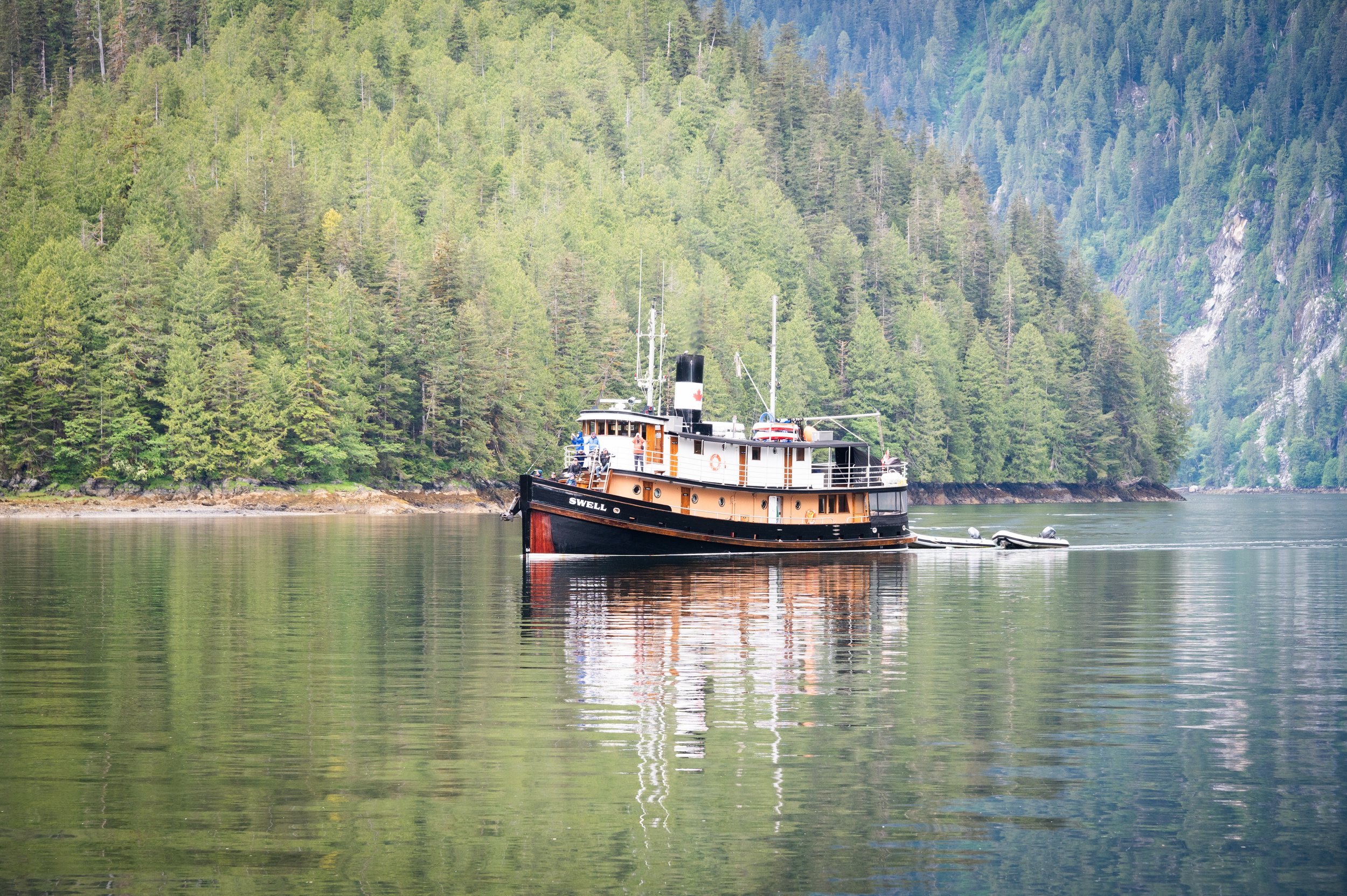
The FUBAR 24 fleet, as they call themselves, scheduled their departure for 8am. Being rafted, we had to depart sooner.  So at 7:45am, we fired up our engines and cast off from Lahaina Sailor.

Conditions were calm and the sun peeked out from the broken cloud cover, a welcomed change. There were lots of waterfalls on both sides of Fraser Reach that caught our attention. The FUBAR 24 fleet, not far behind us, turned up Ursula Channel toward Bishop Bay Hot Springs and we continued our way alone.

beautiful passages

We saw Hartley Bay in the distance as we entered Wright Sound. This body of water can be rough – or at least confused – as it is at the confluence of Whale Channel, Lewis Passage, McKay Reach, Grenville Channel and Douglass Channel. But not today – it was amazingly calm. We saw Fin whales traveling south as we crossed Whale Channel. We saw one large whale and a mom with a calf. Their fins are very distinctive.

We have never been to our destination today, Union Passage Marine Park. You can enter from either Grenville Channel or Cridge Pass. Both ends are guarded by Narrows where you need to enter at slack. Karen chose Peters Narrows off Cridge Pass, as it has a slightly lower flow (max 7 kts) and is deeper.

We entered at 12:02 (low water slack was estimated to be 12:19) and saw less than .5kts of current ebbing. Lowest depth was 14.5’, but mostly we saw depths in the low 20’s. The narrows is very well charted, and we liked entering at low tide to clearly see the obstacles.

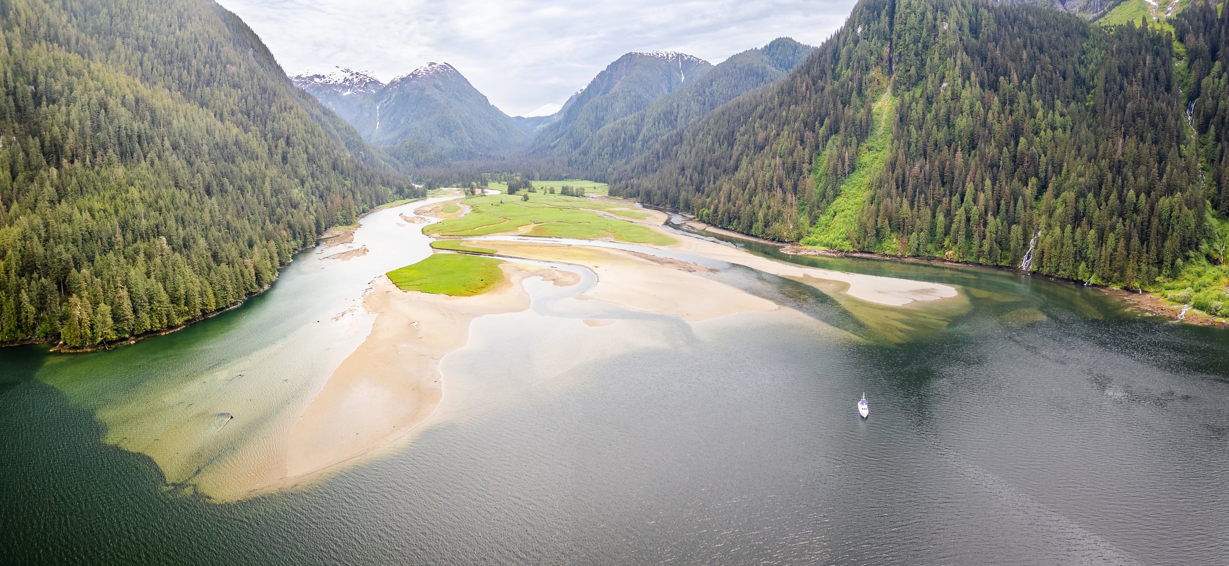
Our original plan was to anchor temporarily in what the Douglass’s call “Outer Cove”, which is just beyond Peters Narrows, and then move into Farrant Lagoon later when the tides were more favorable.

We really liked the look of Outer Cove.  It was very cozy feeling without being closed in. There were several “bear beaches” that looked promising, especially at the head of the cove. So, we settled in to relax before going out for dinghy exploration, as there is a lot of territory to look at.

cozy Outer Cove

we love these types of anchorages

First up was an exploration of Farrant Lagoon. The very few references we found to this area was that the Lagoon was a “ bombproof” and very remote-feeling anchorage. There is a narrow “neck” leading into the Lagoon that has about 1 fathom at zero tide. When we entered (2:48pm on a +5.3-foot tide), we saw no less than 19 feet, though that could vary a lot depending on the route you choose. The lagoon itself is extremely large, and the winds were such that there was fetch from one direction that clashed with the flood tide. It certainly could hold several flotillas, but to us the Lagoon was nowhere as pretty as our spot in “Outer Cove.”  So, on we went.

Next stop was to check out the other entrance, Hawkins Narrows, which leads to Grenville Channel. The current was running when we arrived, estimated about 4.8kts of inflow when we let the dinghy drift. This narrows is less wide than Peters, and has a rock in the fairway.  We’d bring the big boat in at High Water Slack. We took a brief spin out into Grenville Channel, and then went back the way we came. We did see a sea lion pop its head up to look at us as we went past.

Perhaps our favorite part of the exploration was back near Outer Cove, when we looked at the outlet to 2-mile long Tsimtack Lake. We were able to go a short ways toward the lake before being blocked by rocks, abandoned equipment and rapids. We dropped the anchor in the outflow current so I could take some pictures, and then returned back to OceanFlyer to warm up. Total miles for the dinghy trip: 7.6 nautical miles.

as far as we can go

a closer look at the abandoned equipment that bock our way

Later that evening, we spotted a large black bear near the creek outflow at the head of the anchorage.

Khutze Inlet to Butedale

Before we started on our day’s journey, I wanted to see if I could replace the impeller on the 20kW generator. This generator is one of the hardest things to access on the boat and I hate working on it. After removing sound shield panels, spare oil and numerous other obstacles, I was able to reach the water pump and remove the impeller. Unfortunately, along with the impeller (which was still intact and clearly not the problem) came the entire impeller shaft. Apparently, it had sheared clean off.

OOOps!

Emails go out to Shearwater Marine to see if they can get the part and schedule us for the installation in about 10 days when we start to head back south.

Thankfully, all but one other boat left Khutze early this morning in the rain. So, as I did battle with the generator, Karen enjoyed the return to solitude and watched for mamma bear and her three cubs to appear at the waterfall.

As we were leaving Khutze Inlet, we saw four boats on the AIS about two miles ahead of us.

We followed them and Karen started to worry that they were also headed to Butedale, putting potential dock space at a premium because these were fairly large boats. As we continued on, they turned up up Butedale Passage and clearly set a course for Butedale proper.  As they turned into Butedale, I called them on the radio and asked if they were just sightseeing or planning to spend the night.  Turns out they had received permission to stay overnight as we had.

The four of them took up the whole length of the dock, but M/V Lahaina Sailor was kind enough to offer a raft with him. She is a 58-foot Cape Horn, so how could we turn down such a solid berth? It was very nice of them to offer rafting to strangers, and they greeted us with open arms and friendly smiles.

Oceanflyer rafted to FUBAR 24 fLEET AT bUTDALE

It turns out this group has travelled together before, in Mexico. They call this year’s trip FUBAR ‘24, and they have the t-shirts and other swag to show their affiliation. This is their first trip north to Alaska, so we were able to share with them some ideas of places to go and things to do. They are a warm and friendly group who seem to be having a great time together.

It has been eleven years since we were last at Butedale. We have very fond memories of being given a “tour” of the dilapidated facilities including the power generation house,  which used older wooden flumes and newer metal pipes to divert runoff from the large lake to the power generating system. We then were also able to tour the large abandoned cannery building and the caretaker’s house.

IN THE BACKGROUND IS THE LAKE THAT MAKES BUTDALE WHAT IT WAS AND COULD BE

Since that time, the property has been purchased by Inside Passage Marine. There are lots of plans for future development and the property is for sale or joint venture. There has been a lot of decay since we were last here, and some of the buildings have been completely removed. The most visible improvement is the dock, which is now large and secure. When we were here so long ago, it was a bit of a waterlogged, narrow, moss covered, half-submerged mess.

not many buildings left “standing” at Butdale

you can see whats left of the old docks on the left

I still hope, as I did back then, that investors can make a go of fulfilling their vision for Butedale as a major boating destination to and from Alaska. It’s such a convenient stop along the main route and has a storied history. The waterfall is amazing and we’re told the lake is breathtaking.

I flew the drone and got some great pictures of the boats on the dock with OceanFlyer rafted as well as the property itself and the waterfall. We encouraged the folks on Destiny who wanted to see bears to take their high speed chase boat 12 miles back down to Khutze Inlet, and indeed, they saw a bear!

bARN SWALLOWS LOVE OUR RAILING, EVEN IN THE RAIN

Khutze Inlet Lay Day

Another beautiful day in Khutze, at least to start.

Our only companion, the S/V Passing Cloud, left this morning. We noticed the passengers all staring at the waterfall, and right by it was a mama grizzly and 3 cubs. It’s rare to see that many cubs, and they were very playful.

After that, the inlet started to get a bit crowded.  First, we were joined by a Hinckley picnic boat and a small white sailboat. These two anchored at a respectable distance and were able to do so without turning the anchorage into a wakefest.

The the Canadian passenger vessel M/V Swell came in and took the spot in front of the waterfall that had just been vacated by S/V Passing Cloud. I wonder if these two charter ships coordinate their schedules?

m/v sweel arrives in khutze inlet

Swell takes Passing Cloud’s vacated spot in front of the waterfall


Karen has been tracking the first Waggoner Flotilla and thinks their 10 vessels may be joining us later this afternoon. That will definitely crowd this anchorage. As I’ve mentioned, it’s deep and not easy, especially if you enter at high tide like they will.

Sure enough, they stared to arrive in waves. First a 60-foot Grand Banks, following by an Arcturos 50, two 55-foot Flemings, and more.

Karen and I were immediately reminded of our last visit to Khutze, when a boat entered at full speed and waked us so much dinner went flying. These boats came in a bit slower than that, but not as much as you would like. They didn’t slow down early enough to avoid the rocking and rolling.

I also suspect no one had much idea as to what to suspect when anchoring in Khutze. Were they briefed? They would come in, drive toward the “open water” in front of us (that is, towards the mud flats that were covered at high tide) and then slam on the brakes as they saw the seabed rise rapidly.

Then out they would go, stopping again when the depth exceeded 100 feet in just a few boat lengths. They would float there for a while, trying to figure out where to go.

 We saw all manner of anchoring techniques, with too many just dropping their anchor and never bothering to set it.

We were scanning on the VHF and heard lots of dialogue between the boats. Several decided to anchor at the mouth of the inlet, off of Green Spit, where the depths and crowding were less. Despite that, we ended up with at least 10 boats anchored at the head of the inlet. It felt overcrowded for sure. It’s a tough place to bring a large flotilla when there are already 4 boats at anchor in a tricky anchorage.

The two Fleming 55’s in front of us in the shallow water over the mud flats may well luck out as the low tonight is a plus 7.6 feett, but they will need to be gone in the morning before the real low arrives along with the mudflats. Even so, if the winds swing back to the NE, they will awake with their sterns looking at some very shallow water.

In the meantime, the M/V Swell launched her two dinghies, called “Flotsam” and “Jetsom”.  They saw one bear run away from another and thought it might be a bit of a mating dance. Later, the mama bear and her 3 cubs came back out at the base of the waterfall and put on a show for a couple of hours to the delight of all of us anchored in view.

Windy Bay to Khutze Inlet

It’s an early wake-up call to time our arrival at Khutze Inlet at low water.

A low-water arrival lets us get a good look at the mud flats, which extend out further than you think and after often far different than what’s charted due to silting.  We haven’t been here since 2011, so our memories are a bit fuzzy compared to Culpepper Lagoon.  It’s just so much easier to anchor when you can see all the obstructions.

oceanflyer anchored at the head of khutze Inlet on a low tide

Like most Inlets with an alluvial fan, the bottom drops precipitously from the end of the fan. This makes it a challenge to drop in water that is not too deep - we try for a hundred feet - yet far enough from the edge of the mud flats so you can deploy enough rode without going aground. This is important, as inlets can get windy, especially in the afternoon.

My technique is to drive up to the edge of the flats, noting the depths as they rise. I have a minimum depth that I’m looking for – 10 feet under the boat at the lowest tide - and once I find that, I mark it on the chart. Then I measure out my estimated length of rode and motor out to that mark. If the depth at the anchor spot is acceptable, we release the anchor and set it well.

One advantage you do have is that you are backing uphill into the shallow water which gives your rode and anchor a great working angle. This comes with the disadvantage that if the winds blows you away from shore, you are now pulling away from the steep bottom, making easier to dislodge the anchor. That’s why we do not cheat on the amount of scope we use and set the anchor very well with at least three good tugs with power.

Khutze Inlet is about 5 miles long, with a beautiful estuary at the head. We were the only ones here when we arrived, which let us have our choice of anchor spots. It is really a stunning place, with a glorious waterfall, a beautiful valley surrounded by high peaks and a river. The Inlet, river estuary and uplands are part of the Khutze Conservancy, and it is nearly guaranteed that you’ll see bears this time of year.  In fact, we saw brown bears in the distance from the moment we arrived.

previewing the waterways at low tide

As we settled in, we were soon joined by the S/V Passing Cloud, a charter ship we first saw in Shearwater. They anchored just off the waterfall and soon launched their dinghy to take passengers exploring.

entering the slough

We were already out in our dinghy, heading up the right hand side “slough” on a rising tide. That is where we saw the bears from the boat, so we thought we’d start there. The slough, mostly dry at low tide, becomes a navigable waterway through grassy areas at higher tides. We entered the slough with 14’ under the dinghy on a +12.6 foot rising tide.

Soon after we saw bears right at the water’s edge, and dropped the dinghy anchor so we could watch and photograph the bears without disturbing them. One was younger, and the other was larger and more mature. After a while, first one and then the other waded and then swam from one grassy section to another.

i wonder if these two are related, as you seldome see two bears so cloase

they move effortlessly though the marsh and waterways

lots of sitting and chewing. One in a while taking a pause to look around.

We continued down the slough, which was beautiful, and we went a fairly long way, just under a mile in total. We found a second waterfall and yet another bear. When we turned around, we were in 4.5 feet (and the tide was 15.2 feet, just before the high).

As we headed out of the slough to the other side of the anchorage (the river side), the Passing Cloud dinghy headed in. It was great timing, and we all got our own “private bear viewing”.

looking up the valley from the river entrance

The entry to the river is on the far far left of the anchorage as you look toward land. There is a large spit that sticks out, and you have to go around it to reach the entry channel. It was deeper than the slough, but just as pretty. We entered with 13.6 feet under us on a 15.3 foot tide.

the very shallow water and rapids was our stopping point

We went about 1.2 miles up the river before reaching the end of the navigable waterway and had to turn back.  We saw one bear while exploring the river. Most of the shallow water was about 4 feet, the lowest we saw was about 3 feet on a +15.1 foot tide. It definitely is a benefit to visit when there are higher “high tides” to maximize the ability to explore by dinghy.

Between Khutze and Culpepper Lagoon, we had amazing brown bear viewing.

the signature waterfall at Khutze Inlet

Culpepper Lagoon Cove to Windy Bay

The sun was still with us as we awoke, but the forecast is for clouds to build for the next couple of days. But with no rain in the forecast for a few more days, we’re more than happy.

Today’s tides allowed us to have a lazy morning, as our departure wasn’t until early afternoon (high slack is the same time as high water at Tom Bay). As we haven’t seen a soul for days, it was great fun to suddenly see one dinghy, two kayaks and 2 paddle boards coming down the lagoon towards us. Karen stepped out to chat with one of the kayakers. The entourage was from the S/V Walkabout Catamaran anchored outside the lagoon entrance at the head of Kynoch Inlet. We often think we are crazy living in Philadelphia but keeping our boat in Bellingham. These guys have us beat. They live in Australia and keep their boat in Sidney! They chatted for a while, and we learned that they saw bears out there are well – including some mating activity. Apparently they are now scarred for life.

As the afternoon approached, we hauled anchor and were 20 minutes early to the lagoon entrance. We had about 1.5kts of current on the bow as we exited. AIt was easy to maintain a course into the main flow as it got squeezed through the narrows.

As for depth, we saw 23 Feet on a +13.9 tide at Tom Bay. That would equate to 10 feet under the boat at zero tide, so I would only attempt a passage at low tide on a dead slack flow.

Unlike what you may think, it is best not to make your turn to the left  immediately after exiting the narrows. The water is shallower there than on the mud flat side. It is charted, but it is a surprise to see your depth finder coming up as you leave the narrows if you turn too soon.

As the folks from Walkabout Catamaran had mentioned, the wind was quite brisk at the end of Knock Inlet with a moderate white-capped chop. The catamaran and another boat were definitely pitching a big at anchor.  What a change to see after so many days of winds less than 5 knots and calm waters at the head of the lagoon.

This afternoon wind effect is quite common in Kynoch Inlet, and you need to have adequate scope as you set your anchor with the stern to the mud flats.

You cannot tansit kynoch inlet without taking a photo of the signature waterfall at lessum lake

As predicted, the clouds start to build, but we cannot complain after the stellar conditions we enjoyed at Culpepper Lagoon. Our trip through Hiekish Narrows to Windy Bay was uneventful with lovely scenery. We anchored behind the little island in the same spot as we did two years ago. We were all alone until late in the evening, when we were joined by a small sailboat.