Culpepper Lagoon Lay Day 2

Today is our big day of explorations – the weather gods have brought us sun and less wind that yesterday.

beautiful morning to go exploring

grizzley and bald eagle share this breakfast spot

We took a long, 10.1-mile roundtrip dinghy explore the entrance to Culpepper Lagoon. We wanted to confirm the timing we have for low slack water. The head of Kynoch Inlet was calling, and we could not pass up the sunny skies and calm winds.

We went out the entrance at a plus 1.63 rising tide at Tom Bay. The water was flowing at less than one knot. When leaving the entrance, do not make your turn to the left too soon. Continue straight or even favor the right side toward the mud flats. It’s a bit counterintuitive, but the water is deep on that side. Just check your charts and you’ll see how the bottom contours.

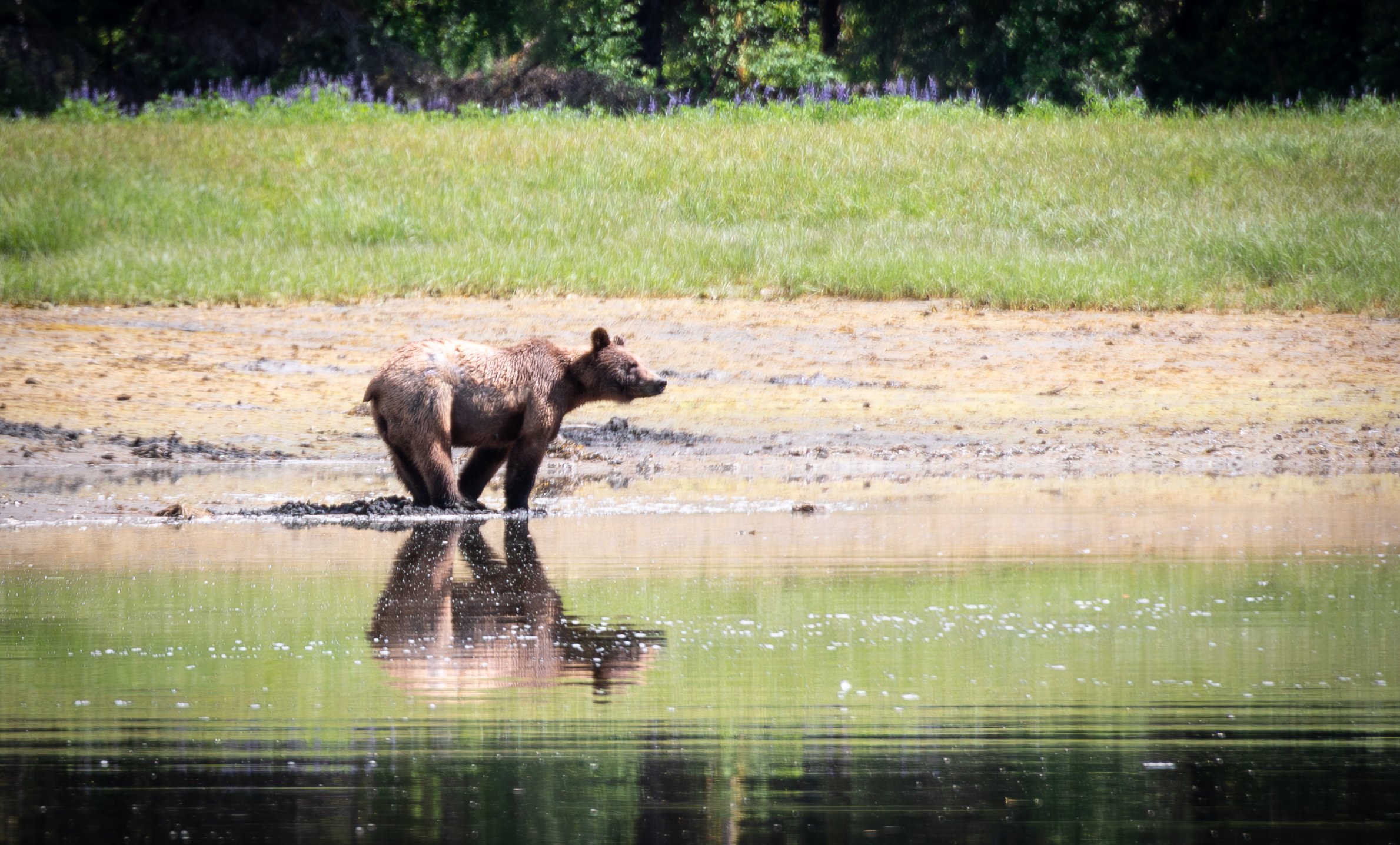
There are extensive mudflats at the head of Kynoch Inlet, which usually means great bear viewing at this time of year. In fact, we saw two brown bears this time. The larger bear stayed on the far side of the creek, but the “younger” bear put on a show.

We sat in the dinghy for a long time in the backwater just inside the flow from the rapids in about 15 feet, watching as the bear made his way meticulously along the water’s edge. We watched him dig in the mud for edibles, leaving behind a trail of upturned mud.  He was determined to find all that he could for his breakfast buffet. It’s funny to see how dedicated they are to finding tasty morsels.

you gotta get your paws dirty if you want to eat

i’m checking you out checking me out

At one point he started digging with one paw and we saw he had found a very large Geoduck- we swear he shivered with excitement and then began to dig feverishly with both paws. It was indeed the biggest Geoduck I have ever seen, and he devoured it with relish.

digging deep for the big reward

sitting down to enjoy a large Geoduck

an after breakfast refreshing drink of freah water from the stream sitting on top of the salt water

We explored up Kynoch Inlet to the first turn to the right, and were amazed yet again at the shear, steep granite cliffs that surround the head of the Inlet.

We headed back into the lagoon on a plus 4.08 foot tide at Tom Bay. We recorded a 19-foot depth in the narrows, and the current was flowing inbound at a couple of knots. There were swirls but they were laminar and there were 10 -15 feet diameter, flat whirlpools on the inside. They were of no significance for the dinghy at these flow rates.

I took the drone up to look at the river with a 8.33-foot tide at Tom’s Bay, that’s about a half tide

darker water indicates the deepest water

planning route around fallen trees

bird’s eye view of the river as it continues back into the valley

After lunch, we launched the dinghy for an explore up the river 1 hour before high tide, so we would have high but still rising water to maximize our trip upriver. Having the reconnaissance photos of the river at low tide was a great aid in planning our strategy to stay in the deepest channels. The photos also helped in planning how to get past the various fallen trees in the river.

high tide at culpepper lagoon

Over the years, I have become more comfortable navigating up rivers in shallow water.  Today, the water was crystal clear and with the sun at our backs, we were able to see all the obstructions and pass safely past rocks, submerged detritus and fallen trees.

clear water makes the bottom seem very close, its about 4 feet

We were able to get up the river about 1 mile, where it turns to a permanent, shallow rapids. Interestingly, this is the same turnaound point we had several years ago when kayaking.  The lowest water we saw on this trip was a brief 3.5 feet and generally never less than four feet until we hit those shallow rapids. As a point of reference, It was a 13.88-foot high tide at Tom Bay.

end of the line

karen grabs a fallen tree as we take a rest in our river explore

exploring rivers is always full of beautiful views

looking back at oceanflyer from the river

Culpepper Lagoon Lay Day 1

We awoke to no rain and a few breaks in the clouds, a big improvement over the monsoon in Rescue Bay. It was also near low tide, so I flew the drone to get some good photos of the low water environment, especially the shoaling at the head of the anchorage. This would be a big help to us when we dinghy up the river at high tide. How, you might ask?  In particular, the low water helps show the best “entrance” to the river which is not obvious at high tide.

LOW CLOUD MORNING AT THE HEAD OF CULPEPPER LAGOON

FROM THE AIR YOU BEGIN TO APPRECIATE THE MUD FLATS

LOOKING BACK TO OCEANFLYER FROM THE NORTH FROM THE BEND IN THE NORTH RIVER

Later we launched the dinghy and began to explore the south portion of the anchorage.  But first, we took the dinghy partway into the river’s entrance to leave a path on the dinghy’s GPS I could later follow at high tide.

THE HEAD OF CULPEPPER LAGOON

As we were exploring the sound end looking somewhat futilely for future stern tie opportunities, Karen spotted a brown bear digging in the mud revealed by the low water. We sat for an hour watching him dig up all matter of yummies from the mud. He was clearly hungry and looked like he needed to bulk up a bit after hibernation. Culpepper Lagoon is usually a “count on” spot to see brown bears.

HUNGRY BEAR ENJOYS HIS BREAKFAST

Next, we took the dinghy back a couple miles to the lagoon entrance to see how strongly the current was running 2.5 hours before slack turning to flood. It was ebbing over 3 knots with a well-defined path. You could probably travel with the current into the lagoon, but I would not choose to enter against this current in my 9-knot boat. The swirling eddies would make for a very interesting ride. I’m sure we could make it at full power, but you’d be exhausted, both mentally and physically, from trying to maintain heading control. Given that slack is well predicted off Tom Bay, it’s easy to time a stress-free entry and exit at or close to slack.

We decided to explore the head of Kynoch Inlet, just outside the lagoon entrance, tomorrow with a better-timed approach and hopefully warmer weather.

On the way back to OceanFlyer, we stopped at Riot Creek to see if we could find a good stern tie option there, but again, we didn’t identify anything particularly appealing. The creek is pretty though.

LOOKING BACK TO THE NW DOWN CULPEPPER LAGOON

OCEANFLYER ANCHORED AT THE HEAD OF CULPEPPER LAGOON

AFTERNOOON RAINBOW AT CULPEPPER LAGOON

We lazed about for the rest of the afternoon, just enjoying the silence and majestic beauty of this anchorage.

Rescue Bay to Culpepper Lagoon

No rain when we awoke. After three days of constant precipitation , what a welcome relief. Today is forecasted to be a transition day. And tomorrow is forecasted to be nice, even touching 70 degrees. Sounds like a great time to head for Culpepper Lagoon.

The Bellingham paper called the weather we’ve been experiencing a weather whiplash. Crappy, then nice for a few days and then returning to crappy.

We must admit that all of the rain is wearing on our morale. Looks like the weather is improving just in time. As we head up Mathieson Channel, the low-lying clouds don’t full cover the beauty of our surroundings. The only plus of all this rain is that the waterfalls are in their full glory. From the tiniest pencil thin flows to the well-known monsters, they are all putting in a show. Most impressive are the falls that reach all the way to the tops of the granite domes, often disappearing into the clouds.

amazing granite domes in Kynoch Inlet

waterfalls everywhere in the rain

Culpepper Lagoon is a long time favorite of ours. It is located at the bitter end of Kynoch Inlet, in a part of British Columbia dubbed “Fiordlands”.  Think snowcapped mountains and granite domes. We first heard about Culpepper Lagoon from the late Brian Pemberton, head of Northwest Explorations in Bellingham and explorer extraordinaire. He encouraged us to visit and not be held back by the narrow entrance from Kynoch Inlet into the lagoon.  Many boats prefer to just anchor at the end of Kynoch Inlet, which is certainly stunning enough. But there’s just something special about venturing into Culpepper Lagoon that draws us back time and time again. It’s even the photo on Karen’s iPhone Home Screen.

Being a lagoon, we do need to transit the narrows at slack, either high or low. There are benefits to each. At high slack, there is more “room for error”, but at low slack you enter the lagoon able to see the mudflats at the head, making anchoring easier.

Local knowledge says slack is timed off Tom Bay Low slack at Culpepper is 1 hour after low slack at Tom Bay, while High slack at Culpepper is the same as high tide at Tom Bay.

We decided to target High Water slack. The low of the day was lower than when we last transited at Low Slack, and we just didn’t want any depth surprises.

We ended up transiting the Culpepper narrows 12 minutes before high tide at Tom Bay. We had about 1.2 knots of current on our stern, and the water was smooth with no swirls. We saw a minimum of 20.5 feet on a 13.8-foot tide at Tom Bay. Yep, we’re glad we waited for high tide.

Although we have anchored here many times and have marks from our 2022 visit, the silting bottom is always a challenge. The water shoals quickly and it’s a balancing act as you drop in 100 feet, let out 300 feet of chain and hope you run no longer worked, so we repositioned our anchor a few hundred feet to the east and settled in. All alone in this magnificent place, it’s truly magical.

there is nothing like culpepper lagon, no matter the weather

There are still low clouds hugging the mountains in here. Tomorrow is supposed to be sunny, so we’ll hold off exploring until then.

the famous waterfall in culpepper lagoon. Good place to look for bears

Rescue Bay Lay Day

Today’s forecast is for even more rain. In fact, there is so much rain today that we just have no interest in going out in our dinghy, even fully wrapped up in foul weather gear.

But we knew to expect this, and would rather be here in the rain that at our next stop, Culpepper Lagoon in Kynoch Inlet, Fiordland. That stop is all about the vistas and exploring, not something to do in the rain if it can be avoided. So we are content to stage here and leave tomorrow when the weather is supposed to break.

So, today will be boat chores, blog updates and some trip planning so we show up tomorrow at the Culpepper Lagoon entrance at High Slack.

More boats showed up in the rain later today, including 2 sailboats and a commercial prawner anchored once his day was done.

rainy lay day in rescue bay

Ocean Falls to Rescue Bay

We awoke at 5:30 for a 6 am departure to find an un-forecast but welcome break in the rain. Karen especially was pleased, as she’s the one who casts off all the lines while I stay dry and warm in the boat.

Our early start was designed to reach the Perceval Narrows near slack, before it turns to ebb. When a strong ebb flow meets incoming ocean swells,  that meeting can create large standing waves or at least an uncomfortable ride, as you’re beam to at that point. For planning transit at Perceval Narrows, the data we used is that the turn to is an hour before Prince Ruppet low tide and the turn to ebb is one hour before Prince Ruppet high tide.

As we made our way down Cousins Inlet, the distant skies were broken with a bit of blue sky showing. The clouds embraced the higher peaks, and the winds were light. A perfect morning. As predicted, when we entered Fisher Channel, the current gave us a nice push. It’s going to be a long 6-hour day, so we expected  to see all matter of wind, current, clouds and more rain.

Rather than retracing our path through Gunboat Pass (although it’s shorter), we turned up Johnson Channel followed by a turn down Return Channel. It added 5 miles to the cruise, but it was worth it, especially as we had not been the way before. Tall 3,000-foot granite domes were in every quadrant. The winds stayed light and the water calm. We passed several bear beaches, and we spotted one large black bear foraging on the freshwater grass.

We also identified a potential anchorage behind Beaumont Island at the junction of Johnson Channel and Roscoe Inlet. It has great looking “bear beaches” and views up Roscoe Inlet. Maybe on our way back later this summer.

As we joined Seaforth Channel, winds rose a bit and we felt the ocean swells. But it was a great ride, and we only saw two fishing vessels, no other pleasure craft.

Reid Passage was placid, and though there were some beam swells as we headed toward Perceval Narrows, we hit it at slack as planned and it was a non-event.

We had planned Salmon Bay in Mathieson Channel as our destination for the night, but the forecast could not make up its mind on overnight winds – both strength and direction.  We adjusted the plan to anchor at Rescue Bay instead. A very popular anchorage at the junction of Mathieson Channel and Jackson Passage, Rescue Bay is a very well protected spot. While the winds west of us out in the Ocean were blowing 30-40 knots, we entered with winds less than 15 knots and no fetch in sight. And we had peaks of sun for most of the afternoon.

rescue bay looking south down Mathieson Channel

We were the first to arrive but were later joined by one pleasure boat out of Victoria and one commercial prawner.

The bay is ringed but what we call “bear beaches” but, as low tide approached and the rain came back in earnest, we did not see any animals.

rescue bay looking north up Mathieson Channel

Our theory is that even the bears are tired of all the rain, and have decided to hunker down as they, and the crew of OceanFlyer, dream of better weather.