Bamfield

Bamfield is an interesting settlement. Spanning two sides of Bamfield Inlet, the “action” is on the West Side but road access and more services are on the East side. We like to spend our time on the West side.

We always enjoy walking on the boardwalk from the public dock to the Bamfield Mercantile grocery store. Along the way, you pass tidy homes - many with private boat docks - the magical fairy kingdom and even the no longer active feral cat community homestead. Bamfield has character.

The biggest downside with Bamfield is there is almost no available transient moorage for a boat our size in season. It’s all about fishing, and the fishermen consume the available moorage. We even wrote to the harbour mistress four weeks before our visit and she said she was booked until September 5th.  So unlike our previous 2 visits, we had to anchor.

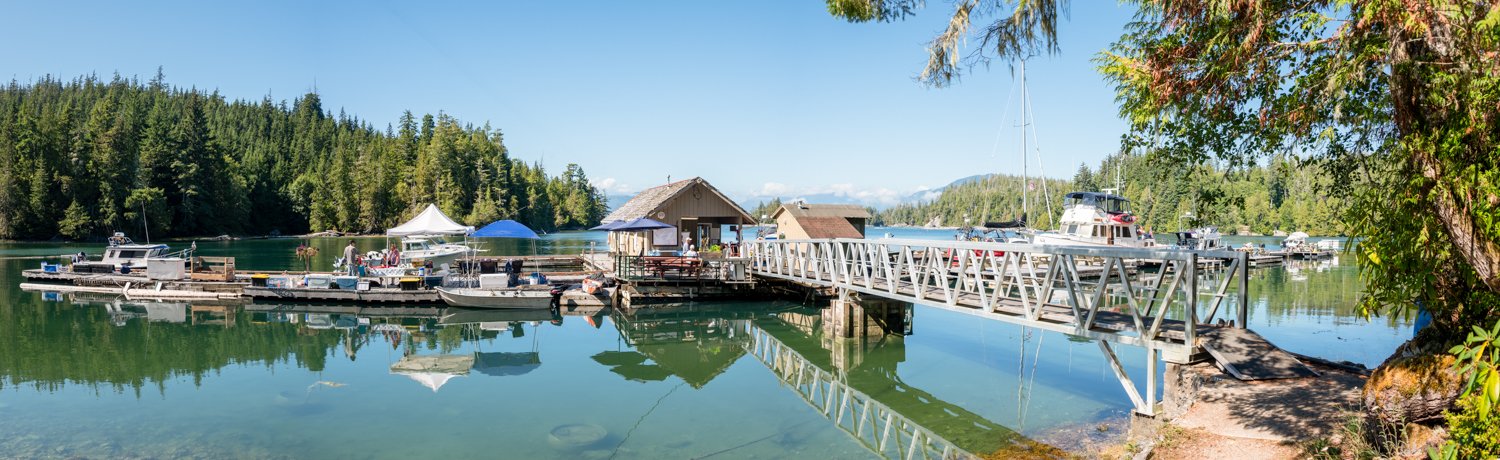
Though many anchor in the Inlet off McKay Lodge, it was crowded and really a bit manic with all the fuel dock traffic and sport fishing boats. So, we chose to anchor in Inner Bamfield Inlet behind Rance Island. It is very peaceful, with the occasional passing sportfishing boat. The Inlet is lined with impressive docks and homes, though none of the homes are intrusive on the anchorage.  There is money coming into Bamfield judging by the homes up in the hills under construction!

The entrance is narrow, but well charted, and the Inner Inlet has good holding in 25 feet. The other consideration when entering this inlet is the overhead power lines at the entrance. The published clearance is 56 feet (Karen swears it is less based on her observation of OceanFlyer going under the wires), so this is not an option for some sailboats. It is a mile dinghy ride back to the Bamfield Mercantile store, but we found the peace and quiet well worth it. Not to mention the 3 bears we saw at low tide, including a Mom and Cub.

oceanflyer anchored in Inner Bamfield Inlet looking back toward bamfield

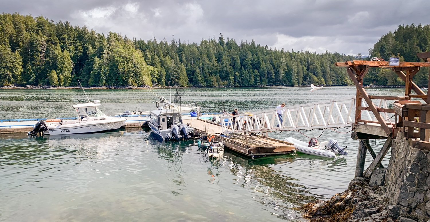
The only issue with anchoring is finding a place to tie up your dinghy when you want to explore West Bamfield. There is no dedicated dinghy dock. The general store allows you to tie up for 20 minutes to go shopping, but they don’t want you to tie up long enough to explore Bamfield. If you can find an unused, unreserved space on the public dock, you can tie up there, but our first day we could not find any place open. A nice small fishing boat that was leaving for two hours, saw our plight, and offered us their spot while they were away. Amazing!

As for dining in Bamfield…we visited the Pacific Gateway Lodge for lunch. Located at the entrance to Bamfield Inlet on the West side, they have their own dock and encourage visitors to tie up for lunch. You can walk up a steep hill or get a ride in one of their golf carts up to the lodge that overlooks Trevor Channel. The view is stunning. The food is just OK.

the dock at Pacific Gateway Lodge

the M/V lady rose heads out of bamfield as viewed from Pacific Gateway Lodge

the Bamfield Wreckage is good eats in Bamfield

However, there is a new game in town, the Bamfield Wreckage. It’s where the old Boardwalk Bistro used to be, right at the Bamfield lodge. We had lunch there on day 2 and it was amazing! A real win for Bamfield, we hope it continues to flourish.

One of our favorite things to do in Bamfield is to walk to Brady’s Beach on the ocean side of Mills Peninsula. We prefer to start the Walk at the Coast Guard Station. It is a bit longer walk, but the grade is less steep. The beach is awesome – lots of sand, driftwood and sea stacks to explore.

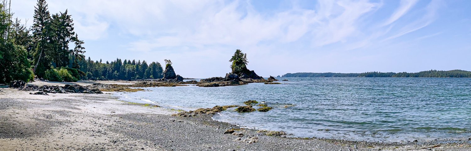
brady beach is long with sweeping vistas

the brady loo is the mostimpressive on the west coast

Another outing we always make when we are in Bamfield is to take the dinghy over to Grappler Inlet and Port Desire. Here you’ll find more homes and lodges, and at high water you can continue to explore to the end of Grappler Inlet. Along the way you’ll be surprised at how many docks and homes are tucked here and there. 

Port Alberni Yacht Club

There is something special about Port Alberni Yacht Club outstation located in Robber’s Passage.

We stopped here on our first visit to the area  in 2012 almost by accident. We were happy to return this year.

overview of the port albermi yacht club outststion. long dock is for visitors.

The Club is built to service the members who primarily use it a base for their sport fishing vessels. They have one dock they dedicate to transients. Moorage “helps pay for the upkeep of the facility.”

It’s first-come, first-served, but we have never been turned away. One time they put on the member dock to accommodate us. Everyone is really friendly and welcoming. They are proud of their facility and the fact that it is appreciated by visitors. They also love to share info about this little gem of a stop.

Behind the clubhouse view of Port Alberno Yacht club outstation

Guests do have use of the showers, but not the clubhouse. Ther is no power and no water and at $1.50 CAD a foot in 2023, it’s not cheap, but we think it’s a bargain.

They have one of the best maintained private trails though the island woods we have experienced. You can visit the beaches on the SE side overlooking Trevor Channel. You’ll find overlooks both to the outside and inside and if you’re up for more than an easy hike, they have trails that explore more of Fleming Island.

Nice walk at the Port Alberni Yacht Club

this way to the beach

one of many little beaches to explore at the port alberni yacht club outstation

driftwood “ART”

overlook to the southeast entrance to robber’s passage. MArk visiable in distance.

Robber’s Passage is a busy shortcut for the local sport fishing boats. They zoom through with abandon, but if you’re not a local, it’s best to go slow and mind your charts. It’s not difficult, but the east end does require attention at the dogleg identified by the red mark. 

says it all

Refuge Island

One of the places that we have never visited is Lucky Creek near the mouth of Pipestem Inlet. It is written up as a favorite stop by boaters and worth a visit. So off we go.

If you read the write-ups and even comments on ActiveCaptain, anchoring nearby can be sketchy. But we had no problem finding a secure and attractive anchorage behind Refuge Island. It’s true, there isn’t a ton of room in front of the oyster floats, but there was enough. The bottom was rocky, but the Ultra held well.

overview of refuge island anchorage

We timed our arrival so that we could dinghy up Lucky Creek at high tide. The approach was silted, shallow — we saw 5 feet in places on a 11-foot tide — and somewhat tricky, but the rest was reasonably easy to navigate. It’s a wide and pretty creek, though not as breathtaking as the Marble River.

We wanted to stop at the head and scamper up the rocks to see the various pools and rope swing, but two kayaks were beached exactly where we wanted to tie off, and we didn’t want to crowd them. One our way out of the creek, we came across a large black bear swimming.

no place to beach the dinghy. kayaks got there first.

We then decided to explore the anchorages behind Bazett Island and the anchorages at Cataract Creek. Though all the write ups imply you need to stern tie, there are clearly opportunities to swing at anchor if you are careful (and if it’s not crowded).  We actually dinghied up Cataract Creek a fair ways, which was a surprise as no one really talks about it.

We then headed up Pipestem just a bit further to the “lagoon”. Entry was easy, and there was a “structure” at the entrance where two people were relaxing. They had set up tents on the structure, and there was a mooring ball for a small boat. Don’t know if it’s owned by one person or is a community thing, but it was cool. The lagoon was very pretty, especially the island in the middle.

surprise structure on the island as you return from visiting the lagoon

It was peaceful and quiet back at our anchorage. We noticed that the smoke building from the BC wildfires was becoming more noticeable. At least it results in colorful sunsets!

Refuge Island sunset

refurge island anchorage not for navigation

Pinkerton Islands

Kevin helped us with a ride back from the Tofino Airport after we returned our rental car in the morning. Our destination today is the Pinkerton Islands. This area is north of the Broken Group. Specifically we like a small one-boat anchorage that is behind some barrier rocks and bordered by shallow flats.

We have always enjoyed this anchorage. The drying rocks give protection from the fetch on most tides, and we have a great view to the south. We’re also hoping that we can get a nice breeze into the anchorage so we can mitigate the heat as the temperature is forecast to approach 80F this afternoon.

Karen has been monitoring on Marine Traffic a boat the past few days that was anchored in “our spot” but, as luck would have it, they had moved on before we arrived.

Back in our spot, we enjoyed being the only boat in sight. There were two boats anchored around the corner in the main passage, but we only knew they were there from AIS.  In addition to the views to the south, there is a large drying flat to the north where we have seen bears and wolves in the past. Like clockwork, we had a bear sighting at a 5-foot low tide.

our favorite nook in the pinkerton islands

one of the local bears walks through “ankle” deep mud as he makes his rounds

cozy home in our pinkerton islands anchorage

Overview of the Pinkerton Island Islands

Karen decided that we were going to go past Equis Beach to Julia Passage, about a 5-mile trip one-way.

Julia Passage was a delight. After working our way through a horde of sport fishing boats at Howard Point, we entered this long no-wake passage that is home to 42 float homes. Each one was detached from the others, on both sides of the pass. No two were alike. These float homes were well kept and ranged from cozy to rather grand. We went all the way to the end of the passage and really enjoyed this small touch of “wilderness civilization”. Everyone we saw — there were some people in residence — smiled and waved.

just a few of the 42 float homes in Julia Passage

On the way back, again weaving through the fishing boats, we saw several salmon caught. Karen clapped for one successful fisherman, and he bowed in return.

floathouse in the western nook can just been seen in the center of this photo

our view as the sun rises in the Pinkerton islands

Joe’s Bay

With the forecast for a few days of strong winds, we decided to make the run from Kennedy Cove to the Ucluelet area today. Conditions were as forecast with light winds and 3-4 foot gentle ocean swells. We enjoyed a pleasant trip south with not much to remark on except for the unexpected crab pots in the ocean at the 150-foot depth line.

As I always say, you know when you’re near Ucluelet when the horizon fills with small boats bobbing in the swells as they troll for salmon. Today was no different. We lost count on how many we passed, dodged, and otherwise avoided. Throw in a couple of kayakers fishing in 4-foot swells and you have a busy approach to the entrance of Carolina Chanel. In reduced visibility, my preferred entrance is to pass by Carolina Channel and enter the area using Loudoun Chanel. You will not find the flotillas of small fishing boats, most without AIS or radar, which makes this 2-mile addition to your journey much safer.

We’ll pass Ucluelet for now and return later for some light provisioning and a planned meal at Pluvios restaurant.

Therefore, we set our destination for Joe’s Bay in the Broken Group. It is a large, if not commodious anchorage, with easy anchoring, good holding, and protection from the winds. Perfect after a 5-hour run.  We dropped the hook in just the right spot, with views out a narrow passage that covered and uncovered depending on the tide.

LOTS OF ROOM IN JOE’S BAY

As we dropped the hook, we noticed a large motoryacht anchored in a corner with a ton of people on it. Turns out this is the Raincoast Maiden, a 53’ day-tour boat that offers a trek through the Broken Group from Ucluelet. They were having a lunch stop and were rather boisterous. Luckily, they soon left, talking on the loudspeaker as they went. We ran into them several times during our stay in this area.

The bay wasn’t particularly crowded, with everyone well-behaved in terms of anchoring space. Once again, we were surrounded by Sailboats.

We went on dinghy explorations just to snoop around. We exited the narrow passage ahead of our anchor spot, tooled around, scoped out the kayaker beaches and nosed the dinghy up to several pocket beaches so Karen could get off, walk a bit and look for shell treasures.

There were lots of kayakers in the area, as Joe’s has good campsites. We noticed the Clayoquot Whaler come into the anchorage twice a day to pick up or offload kayakers. The captain was a great boat handler and was fun to watch. On one visit, he was dawdling and drifting near OceanFlyer while waiting for a kayaking group to get to the pick-up beach and prepare for loading. Karen waved and the next thing we know, he is rafting to us and gifting us with a lovely salmon. We traded some whiskey in return and everyone was happy.

ANOTHER PICK-UP FOR THE BUSY Clayoquot Whaler

MOTHER NATURE DOES NOT DISAPOINT

We also had some lovely sunsets in Joe’s ‘Bay. It’s a favorite stop in the area.