Draney Inlet Lay Day

Today is the day.

We have traveled the 1.5 hours up the inlet to position ourselves to go up the Lockhart Gordon Creek at high tide.

Yesterday we sat and gathered information for the dinghy journey. We watched a full tide cycle and took drone photos at various tide levels. All this informs our route planning and gives some level of confidence before making the trip.

One hour before the high tide at the Draney Inlet reporting station, we set out on a lower-high tide of 10.29 feet. My tide charts indicated we would be on a still rising tide and would have two hours before the water returned to the same level, plenty of time to explore.

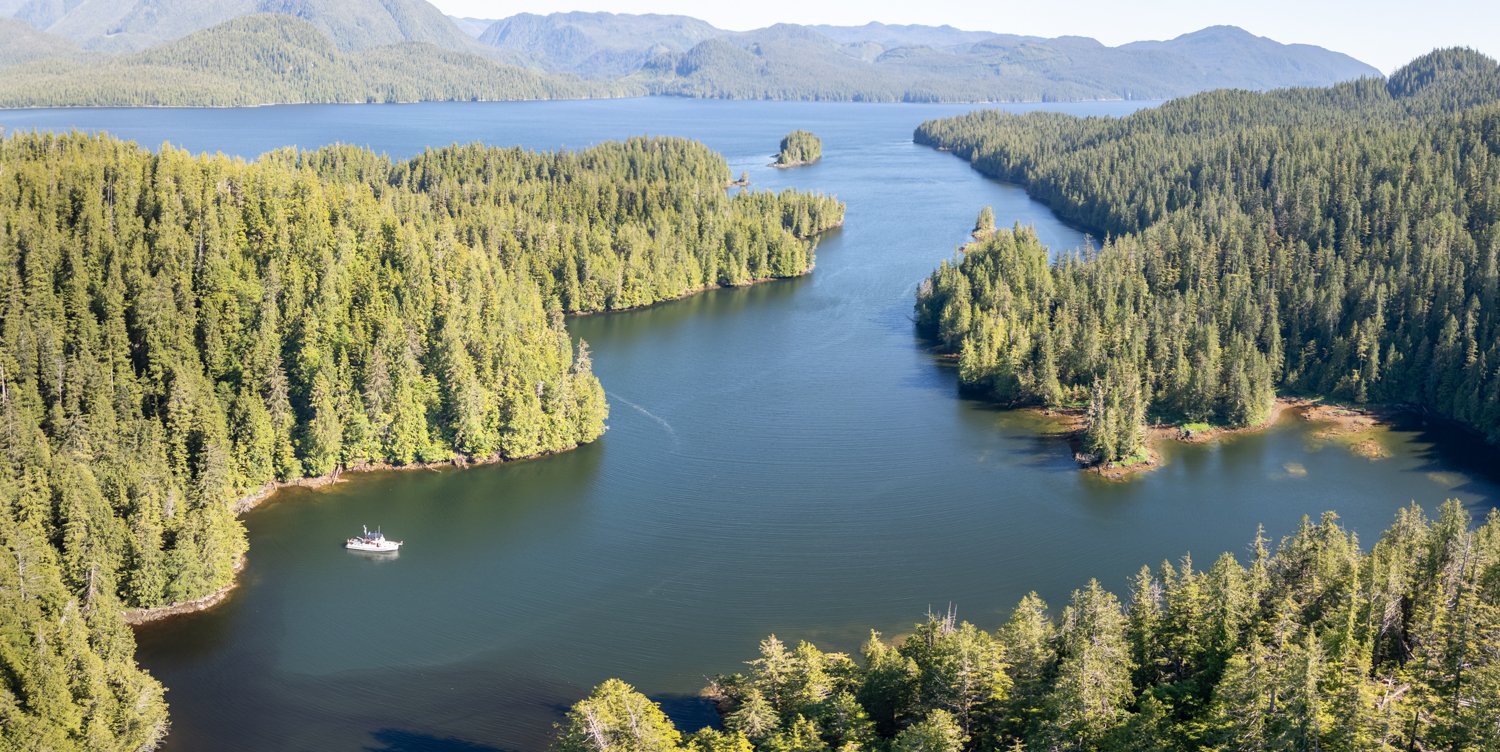
The route I planned was to leave the island on my starboard side and then turn left and north, setting a course toward the large pile of debris at the north side of the inlet. Coincidentally, there was a very visible current flow marked by water smoother than the surrounding water featuring a trail of visible surface bubbles.

This current flow was almost identical to my planned path, so I positioned the dinghy in the middle of it and split my attention between the depth sounder and the water. This outer approach saw depths from 7-8 feet with an occasional 6 foot. I saw only a few obstacles that were sunken logs. Generally, no factor.

Island on the right. DeBris Pile on the LEft. THe stream of bubbles I followed on this day.

As you pass the landslide debris you start to enter the more defined deeper water that runs along the north side. I had picked out a few major logs in the photos that I thought would be visible at today’s higher water. Using them and the current flow as guides, we made our way into the river proper.

entering the river proper

The river is flanked by grassy growth on both sides at it meanders at about 10-ish feet of depth.

Following my instincts from going down many rivers, we made our way until we saw a large tree downed across the river. These are commonly known as sweepters by kayakers as they tend to sweep kayakers out of their vessels as they try and sneak under.

the water shallows as we approach our first sweeper

As we got closer, I saw that the tree did not go all the way to the opposite shore. It actually fell 8 feet short of the opposite shore. The question then became is there enough water that close to the shoreline to pass. Only one way to find out. I approached slowly, taking the raised engine in and out of gear while maintaining one eye on the depth finder and the other on the pebble bottom.

can we sneak but this sweeper?

We made it past with 1.7 feet under the dinghy, and then the depth held at about 3.6 feet for a while.

Our next sweeper was a much larger partially fallen tree. It lay at about a 20-degree angle. As we approached, it became apparent that there was enough clearance to take the dinghy underneath without being “swept over”. All we needed was enough water where we planned to pass beneath.

we’re going to have ot go under this sweeper

That depth was about 1.6 feet, and we continued at that depth, eventually reaching the terminus marked by rocks and tree debris. It took us about 40 minutes to get to the head.

All in all, we traveled about two miles to the head of the creek from OceanFlyer. It was less of a challenge than the photos first showed. We had enough water, sun at our backs and a realistic preview from the drone photos.

The river is really pretty, and we dropped anchor a few times on the way out to just sit back and enjoy the view. It’s clearly bear territory, but we didn’t see any, despite keeping a sharp eye out.

Later, though, as we were relaxing after stowing the dinghy aboard OceanFlyer, I looked up and saw a critter in the grassy outcropping behind the boat. I called out “critter” because it first I thought it might be a smaller mammal.

But we shorty realized it was a grizzly that came to attack the tall sedge grass. Karen noted just how big his head and ears were. We watched for almost an hour as he enjoyed the buffet on an outcropping. Looking through the binoculars, you could see he was stuffing that sedge in with a passion.  To our surprise, when he was satiated, he then jumped in the water and swam at least 50-75 yards to a small islet that was attached to the shore via a fallen tree land-bridge. He climbed out, shook off the saltwater and disappeared into the woods.

time to start the swim home

a quick glance over the shoulder before disappearing into the woods

Draney Inlet isn’t a place many cruisers explore, but we really enjoyed it and thought it well worth the visit. The fact that there wasn’t another boat around made it even more special.

Taylor Bay to Draney Inlet

Today we’re off to explore Draney Inlet.  I was looking around on the charts for something new and found this inlet that is guarded by a narrows with significant current flow.  The Hamiltons write about exploring Draney Inlet in “The Secret Coast”, and they were high on Draney.  We tend to like similar anchorages and explorations, so Karen was sold.

It’s only a couple of miles from Taylor Bay across Rivers Inlet to Draney Inlet. Low slack at the entrance was forecasted to be 8:30am. As we approached the dogleg entrance from Rivers Inlet, the current was still ebbing notably.  We waited another 15 minutes and it was still ebbing, but a bit less. We decided to go for it and found the current – especially in the dogleg – to be running 2 to 4 knots outbound, on our nose. Passage was fine, but some hand steering was needed to keep OceanFlyer pointing in the right direction when she got into certain parts of the current flow. Because the dogleg makes the passage blind to opposing traffic, a Sécurité call is warranted.

Having the current in the bow was fine, but I commented that I would not like to make that passage with that much current on my stern. Later, Karen found an old youtube video of a tug towing a log boom through the narrows. That had to be challenging.

Clearly, published slack was not correct. Upon further investigation, there is an asterisk that says “based on local knowledge.”  Perhaps the local knowledge is right on some tidal exchanges, but not this one.

It’s 12 miles to the head of the inlet, our final destination. Impressive granite mountains, waterfalls and numerous landslides lined both sides as we made our way to the head, right off the Lockhart Gordon creek delta.

Impress scenery in Draney Inlet

We anchored in what would be 72 feet of water at high tide and set a 4-to-1 scope, backing down uphill to the end of the rode until we sat in 40 feet.

Backdpen toward the alluvial Fan

A 10-20 knot breeze held held us steady within our anchor circle and kept the boat cool and the flying bugs at bay.

We had read about excellent dinghy exploration territory up the creek at high tide. I have to say, the low tide view of the delta/alluvial fan of sediment we needed to cross was a bit daunting. There was no obvious pathway through. Lots of deadheads and tree stumps and sandbars.

 We launched the drone at low tide to get a good preview of the creek itself and help determine the best route across the delta to enter it tomorrow in the dinghy. We also launched the drone at higher tide, to get a sense of what landmarks would be visible to help us navigate tomorrow. Based on the drone photos, I knew this was going to be one of the more challenging entries we’ve done in a while.

looking for the path into Lockhart Gordon creek

looking back down the inlet

staring to move up the the approach to the creek to record as much inforamtion at low tide

the start of the creek itself can be seen on the right side

i printed out these photos and took them with me in the dinghy

another look from the creek toward the west most inlet

incoming tide makes for a very differnt image

We shall see what tomorrow brings!

Bitter End Cove to Taylor Bay Via Dawsons Landing

After some morning low clouds, the sun took over and we were greeted with clear skies and bright sun. A noticeable change. Today we are positioning ourselves to be ready to enter Draney Inlet (in Rivers Inlet) at slack tomorrow morning.

clear and calm

We charted our course to take us past Dawsons Landing, to stop in and see the state of this iconic establishment in Rivers Inlet. As we have read in other sources and seen with our own eyes, Dawsons seems a little bit more run down each time we visit, although still fully operational. The store – though reasonably well stocked -  is still half the size of the old days,  a change made during Covid that was never undone.

dawsons landing

Fuel continues to be available, and we were able to pick up a few basics at the store to fill holes in our larder.

large green roofed building is the stor and the fuel dock at the red roofed building

the same logs always seems to be here, but how can you tell on from the other?

We knew virtually nothing about our final destination for the night, Taylor Bay.  Folks we met on the sailboat Aurora II told us they had heard there might be bears. Bears and close to Draney Inlet? Done. The anchorage in Taylor Bay turned out to be a bit cozier than our usual choice, but the holding was good in rock and mud and we were all alone.

Taylor Bay is smaller than it looks because of shoaling

looking back in talyor bay

Rivers Inlet in the distance

The promised bears never came but we enjoyed our brief stay nevertheless.

Bitter End Cove Lay Day

We had such great plans to dinghy-explore yesterday, but the gusty winds and whitecaps kept us boat bound. This morning, we were determined to get out and go exploring before the afternoon winds came up.

Karen had an itinerary for us: Oyster Bay (written up as a preferred spot), Fish Trap Bay and Waterfall Bay. So off we went!

We had visited Oyster Bay several years ago, but it was rainy and overcast, and we didn’t stay. We were looking forward to seeing it in the sun. Our opinion: it is fine, some views but not amazing. Lots of places to anchor, but the depths are such you have to anchor a good way off the small waterfall. Certainly protected from winds and fetch, but we definitely prefer Bitter End Cove.

head of oyster bay

On to Fish Trap Bay.  This was written up by the Hamiltons (Jennifer and James), and they liked it. We tend to agree with their POV, and this was no exception.  The anchorage feels quite open, but the views are nice and in the right weather, we definitely preferred it to Oyster Bay.

Last stop – Waterfall Inlet.  This is a longer inlet, and pretty much landlocked and we didn’t feel the need to go all the way to the head. Big, wide, open, OK.  But there is an interesting smaller anchorage not far from the entrance called Remotesville Cove (named by the Douglasses). It is in the SE corner of Waterfall Inlet, and if we were going to go to Waterfall Inlet, this is where we’d anchor. But once again, not nearly as appealing to us as Bitter End Cove.

oceanflyer in better end cove

looking back out of bitter end cove

 Did I mention we haven’t seen another boat on our journey?

As we headed back to OceanFlyer, the wind and waves had definitely picked up. We had timed our exploration well, and I had to tack the dinghy a few times to minimize the impact of the fetch.

Once back at Bitter End Cove, we went to the very head, to check it out again. Yesterday it felt narrow and not as interesting as where we dropped the hook. We still felt that way, as there is a large shoaling shallow area at the head that keeps you from getting close to the small creek and landing area.

looking up to the end of the head of Bitter End Cove

We then went back near the boat to check out the waterfall that makes up part of our view. It’s small, but lovely and has such a nice sound. Total round trip: 10.4 miles. Fun!

you can trace the path of the water by the light green foliage

the water fans out as it meets the rocky shore

looking down on the terminus of the waterfall

sunset in Bitter End Cove

South Sea Otter Cove to Bitter End Cove, Fish Egg Inlet

We were undecided where to go after Sea Otter Cove.  We were biding our time a bit, as we worked our way south toward Draney Narrows in Rivers Inlet, our next big adventure.

watching the clounds over fitz huh sound from sea otter cove

Karen left it up to me to choose our next anchorage, so I chose Bitter End Cove at the very far end of Fish Egg Inlet as our next stop because we have never been to this anchorage and it looked as if it might be a place to see bear.

Leaving Sea Otter Cove, we had sunshine for a change. The winds were calm as we entered Fitz Hugh Sound. The water was barely rippled, with just a slight swell in the water.

As we make our way south the wind begins to increase from our stern. The sound got confused and choppy as we are abeam Hakai Passage which is open to the pacific.

By the time we got into Fish Egg, there were whitecaps. As we approached the Narrows, we saw blows and slowed to enjoy the two humpbacks before continuing.

As we approached Bitter End Cove, it was clear that this cove was not protected from the wind or fetch. There were two possible anchor spots, and we chose the one opposite the small waterfall rather than the less attractive (to us) head.

I suspect many boaters would have decided to find a more protected spot, but the anchor bit soundly and OceanFlyer is heavy enough that the fetch wasn’t noticeable. The winds kept the boat cool in the sunshine and we were quite happy with our spot. There were views in all quadrants and not another boat in sight.

Our plan to fly the drone and go dinghy exploring was put on hold until tomorrow, due to the winds and the big whitecaps out in the bay where we planned to go.

Bitter end cove sunset