Quigley Creek Cove to Tom Bay

5:15am and the fog has descended upon our anchorage. In fact, it’s zero/zero. Back to bed, as our scheduled departure is not until 10:30am.  It’s not a surprised that the sun is hiding. The forecast has turned to a long string of cloudy and rainy days.

Our departure time this morning is based on Meyers Narrows, the protected route that takes us “back inside”.  I picked a tide height and current that I was comfortable with (having transited this passage several times), saving us a couple of hours waiting for the exact moment of high slack.

We went throughthe narrows on a +9-foot tide and saw no less than 11 feet under the keel. The current was on our stren at 2.5 knots which presented no problem going through the well-charted narrows. Karen made a note in the logbookl that +9 foot was a great tide highet to target our passage.

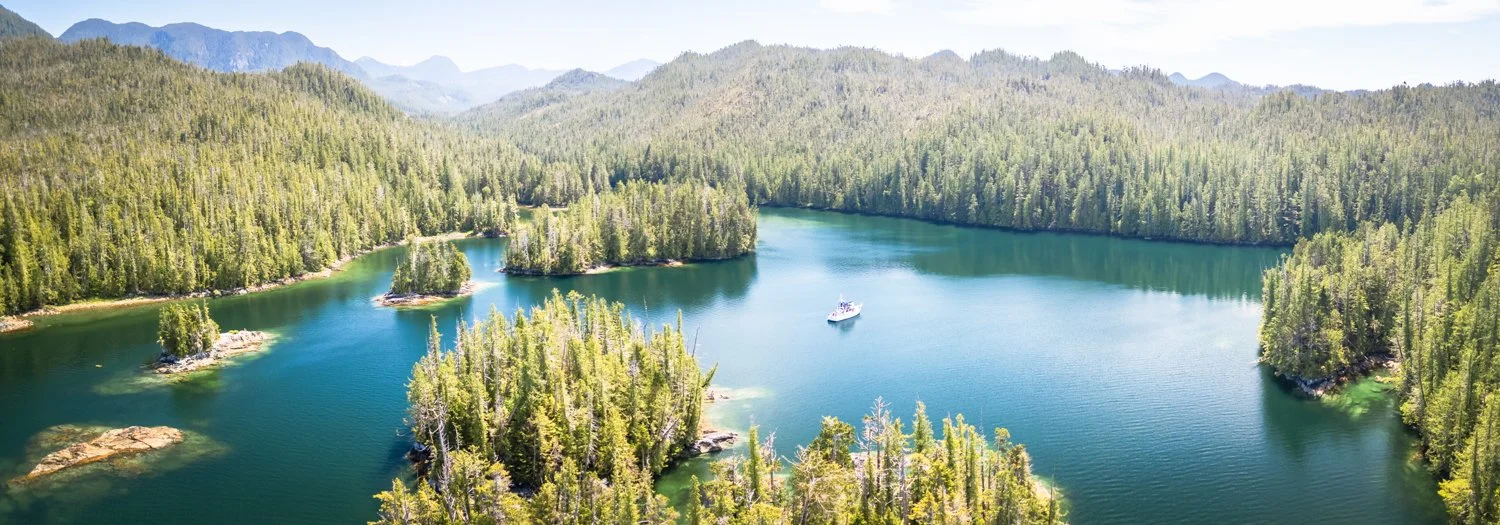
Our original plan was to take Thistle Pass to Meyers Narrows, turn right at the top of Meyers Passage at Tolmie Channel near Boat Bluff Lighthouse and then head down Finlayson Channel to Jackson Pass and anchor in the one-boat hole just before the narrows. But the timing to depart at slack the next day was not favorable, so we decided to take Oscar Pass instead to our destination of Salmon Bay on Mathieson Channel, about a 5 hour run. Our decision to head south was driven by the need to arrive at Shearwater on a specific date to pick up a new sea water pump for our 20kW generator.

the unmistakable Boat Bluff Lighthouse

Karen took the helm as we approached Boat Bluff and Klemtu. Though still cloudy, the wind was up, and we changed course a bit to minimize the beam seas (and dodge logs).  Many boats were heading north, probably toward Alaska. One was Rushmore, a very large yacht we saw last year on the west coast of Vancouver Island.

Oscar Pass was, happily, more sheltered due to the wind and waves being on our stern. But as we exited, we quickly saw that the wind and fetch was heading straight into Salmon Bay, our planned destination. Time for an alternative. We chose Tom Bay, despite not knowing much about it, as it was just a bit further south and was oriented for protection from the prevailing wind.

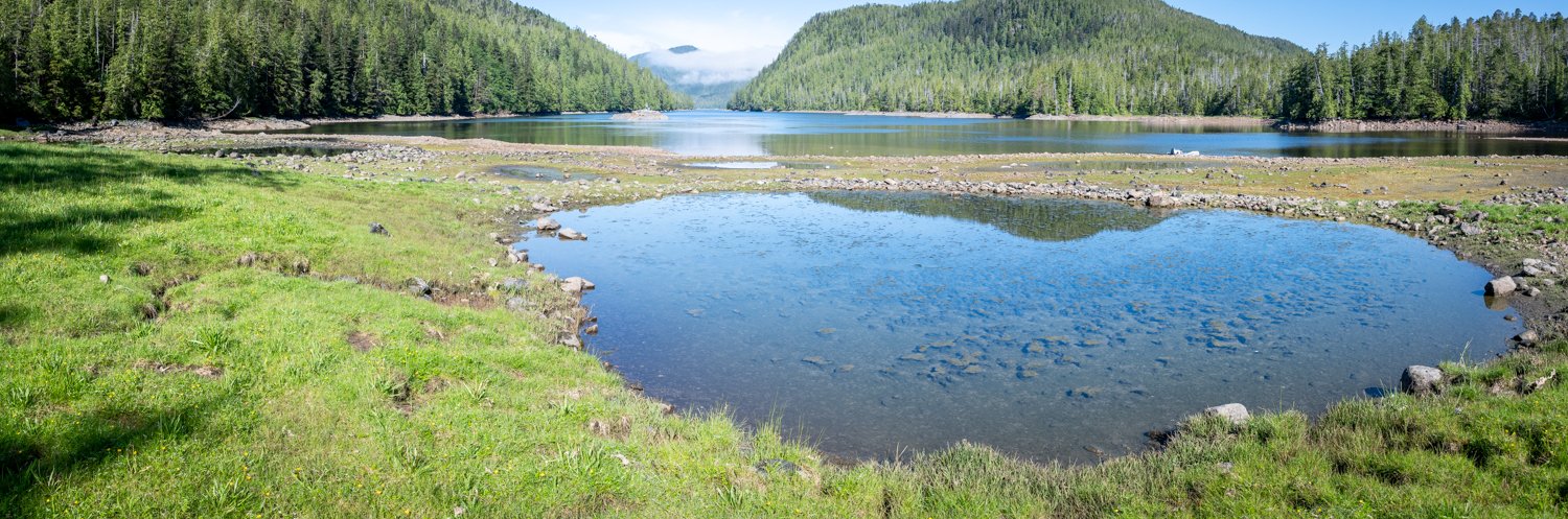
Tom Bay is attractive. There’s not much written about it, but it’s easy to enter, has nice views and there’s a great “bear beach” at the head. In fact, not long after we anchored, a black bear prowled the area for a while. Later that evening, another black bear (fatter) was eating sedge grass and even laying down in the grass, when it heard something and scampered post-haste into the woods. Shortly thereafter, another black bear came into view. That one also enjoyed the sedge and explored a bit, until it sniffed the area where the other bear had been and it ran into the woods, maybe chasing the scent. Mating season?

Tomorrow we head for Troup Narrows Cove.

Alston Cove to Quigley Creek Cove

This morning’s mission is to dinghy up to the head of the cove and explore the circular fish traps/weirs. We saw these in 2022 and wanted to see them again.

First thing this morning, I took the drone up one more time to look at the approaches to the head of the cove at a low tide of 1.24-feet at Milne Island. These photos, combined with those from yesterday, gave us a very good preview of what our approach should be. It looks like there is lots of water, but it really gets shallow once you are past the large rock.

beautiful morning at alston cove

the approach to the fish traps

this shows the structure of the shallow water at thehead of alston cove

At a 5-foot tide at Milne Island, we saw no fewer than 3 feet of water on our dinghy trip to the shore. I tried to stay in what I thought was the deepest water carved out by the creek on the south side, but no matter, we had enough water.

The best thing about the timing is we had a nice approach and landing on a medium steep rocky shoreline. It was easy to get off the dinghy and secure it to some larger rocks upshore.

Easy landing for the dinghy

it is a short walk up the rock encircled fish traps

We walked along the creek. It’s pretty, but I don’t think you’d get very far upstream even at high tide due to all the rocks. Using Kayaks and portaging over the shallow rapids might work, but we’ll leave that to the more adventurous.

karen scoping out the river to see is we might make it up in the dinghy

We then then walked over to get a look at the circular fish traps. It’s easy walking with a mix of stone, reasonably solid marsh, and firm mud.

view from the fish traps back down alston cove

overhead view of the fish traps

About four of the seven circular fish traps are still intact and held some water at the lower tides. They’re really cool to see.

one of the large fish traps that is still intact

Back to the boat and then off to Quigley Creek Anchorage, which is right at the mouth of Laredo Inlet, about 45 minutes run. It’s a popular anchorage, as it’s not far beyond Meyers Narrows and is just off Thistle Passage.  We were here in 2022, but shared the anchorage with 3 other boats, which was a bit tight given that it’s also a deep anchorage.  The weather wasn’t great when we were here before, and we didn’t explore the creek.

quigley creek cove viewed from the creek entrance

oceanflyer anchored in quigley creek cove

Today is sunny and the tides are right to explore the creek as far as we can at high tide. We entered the anchorage to find it empty, so we could choose our spot. At 1:25pm, we were off to explore. We found 15’ at the entry to the creek on a 12.6 foot tide at Milne Island. It’s really pretty, and we made our way as far as we could, abput one mile. It got quite rocky and we read about 1.8’ on the depth sounder, so we turned around, found a slightly deeper spot and dropped the anchor to just enjoy the peace and quiet and take more pictures.

looking up quigley creek from its entrance

Quigley Creek

After a while, we headed back down the creek, ready to explore all the islets around the anchorage. Unfortunately, we also noticed that the tell tale was no longer streaming water on the dinghy engine. I was really worried, as it would have been a very long row back to OceanFlyer, but I was able to continue under power without overheating the engine – I kept a close eye on the temperature gauge. Nevertheless, we made a beeline straight for the boat to troubleshoot.

Given that the engine didn’t overheat, it pointed to a blockage in the water line to the tell tale hole. I cleaned it out – not finding much – and then dropped the dinghy back into the water to test it. While there was “some” water flowing, it wasn’t normal. Up went the dinghy again, and I tried more aggressive cleaning. I found some black tarry stuff that seemed to be the culprit. And voila – the engine was “peeing” like normal.

 We went out to explore among the island and islets. It was sunny and calm and we had a great time.

The weather is supposed to change, so we soaked up all the sun we could. When we turned in for the night, we were the only boat in the anchorage.

mother nature puts on an impressive show

Chapple Inlet to Alston Cove

Today we head for Laredo Inlet and return to Alston Cove, last visited in 2019.

The weather was bright and sunny, with totally calm seas. The best kind of travel day.

there is calm and then there is this kind of calm

Departing Chapple Inlet, we saw a deer posing at Doig Point. Karen swears we saw the same deer in the same place in 2022. Interesting. This deer waited until we were in good visual range, pranced out of the woods, and then stood there in her glory for adoring fans.

Exchanging glances with the locals

As we turned left into Camaano Sound and the start of Laredo Channel, we could see Haida Gwaii 80 miles away.

We remembered Alston Cove fondly from our prior trip and were interested to see the fish weirs at the head of the bay again. Alston has a cozy feeling due to the narrowish entrance,  despite being spacious once inside, with a pretty valley at its head.

No boats were seen in Laredo inlet as we made our way towards Alston Cove and we had the Cove completely to ourselves for the evening.

McMicking Inlet to Chapple Inlet

 After a great day of exploring the beaches in McMicking Inlet it is time to move on. Karen found an extra day in the schedule, so we’re going to go only 23.3 miles to Chapple Inlet.

The southwest tip of Campania Island has been a reliable spot to see humpback whales, and this year did not disappoint. We saw a pod of five whales. They were making lots of blows in unison.

lots of humpback blows

From a distance I thought it might be bubble feeding, but as we got closer it felt more like they might be herding their prey into more shallow water. There were a couple of small recreational fishing boats in the general vicinity, so that’s probably what was happening. We stopped and watched the whales for a while before continuing on.

We visited Chapple Inlet in 2022, and really liked it so Karen decided we should make a return visit. It’s a long way back to the head, but that’s our preferred spot. As we worked our way into the Inlet, we passed two sailboats who were departing Kiln Bay.

We continued to the very head of the inlet. The shoaling and reefs are well marked on the chart. At low tide the obstructions are mostly visible, but at higher water it’s best to mind the charts and go slow. There are a couple of narrow spots that deserve attention.

 At the head, there is lots of room to swing and the holding is very good in 30-40 feet over mud. It was sunny and we mostly lazed about enjoying the weather and the views.

looking back at oceanflyer from the head of chapple inlet

a good look at the shoaling in chapple inlet

We kept a sharp eye out for critters. No bears, but we saw two sandhill cranes.

Very late in the evening we were joined by a Ranger Tug. The tide was high, and we were worried because it appeared to be on a course towards the charted rocky shoal.

They poked around for a long time and finally dropped anchor. About 45 minutes later, we heard them raise their anchor and reposition themselves 200 feet to the south. My guess is they swung over the shoal, and after doing some math, realized that their location would be a problem when the tide goes out.