Horsefly Cove (Green Inlet) to Khutze Inlet

We had another early call, as the tides and currents said that an early departure would make the best travel to Khutze. Unfortunately, an early call after last night’s anchor watch was a bit difficult! Still, we decided to get up and go.

We retrieved the stern tie with no problems, and headed out Tolmie Channel and Graham Reach for Khutze. The only problem was that riding the favorable currents meant that we’d arrive at Khutze at high tide. Khutze is another anchorage with mud flats and silt from the Khutze River and the waterfall, so it meant that finding the elusive anchor spot would be more challenging than at low tide.

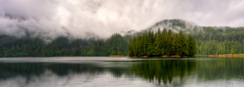
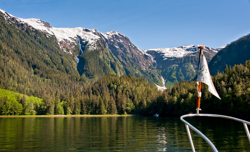
As we headed north, we saw the old cannery ruins in Swanson Bay, but no one showed up on AIS. As we neared the entrance to Khutze Inlet, a small fishing dinghy came tearing out and made a line for us. He wanted to know if we’d seen a white prawn boat in the vicinity. Bob had noticed it behind us by a few miles, and he shared that with the dinghy driver, who sped off to the south. As we entered Khutze, it started to clear some. We passed Green Spit anchorage, which to us seemed kind of ho-hum, unless you just needed a place right off the major pass to lay down the hook. We continued to the head, encountering dissipating fog.

Horsefly Cove to Khutze Inlet-68_69_70_71-Edit

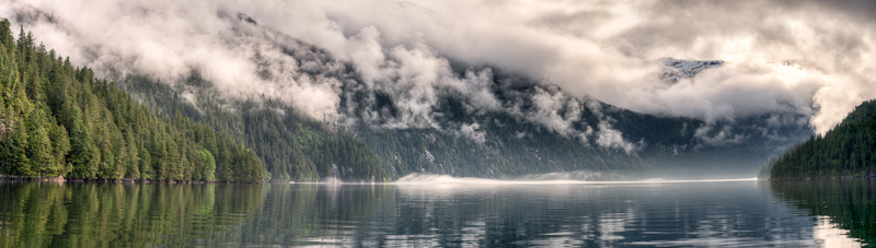
Fog was giving way as we enter Khutze

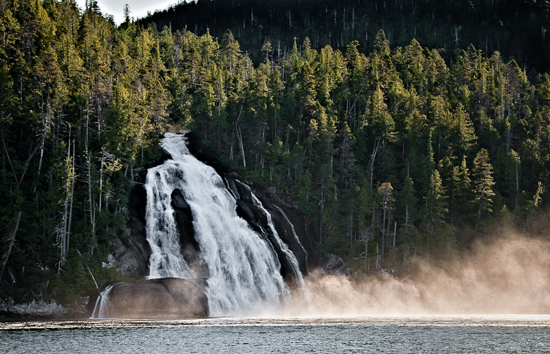
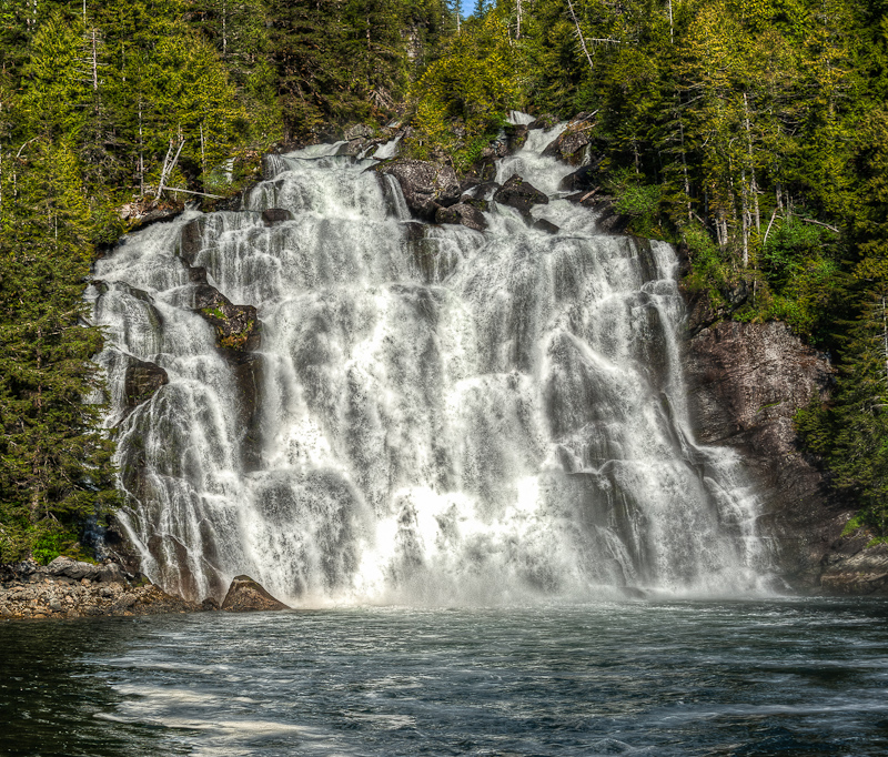
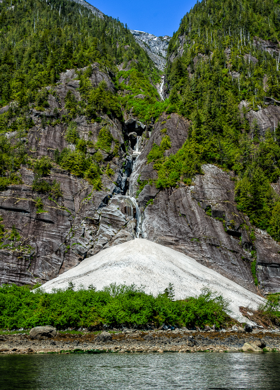
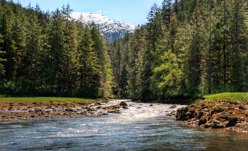
The head of Khutze is lovely, with a very large green valley sandwiched between mountains. There is a very pretty waterfall on the right (as you face the head) and the Khutze River empties to the left. Finding the anchor spot was a challenge….it was quite deep, and then the mudflats came up sharply. Bob’s diligent plotting coupled with my adding marks to the electronic charts with depths helped us see the spot. We dropped 300’ in 100’ of water and set the hook well. Based on our calculations, we would never swing into water less than 40’ deep.

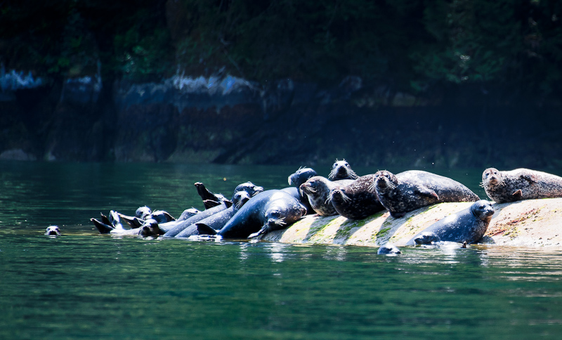
Bob took a short nap to fight off the ills of the previous night’s anchor watch, while I read all day.  It was cool out, but not windy, and there were lots of seals and gulls to watch, along with an occasional eagle. As the tide went out, the picture was so very different. You could clearly see the mudflats as well as the uncharted silt spits emanating from the Khutze River and also over by the waterfall. At anchor, we were often dive-bombed by swallows – three of them kept coming over to the boat and trying to fly in the windows. We had to close them to keep the darned things out. And we were once again visited by a hummingbird, though the closed windows also kept him from coming inside to say hello.

Horsefly Cove to Khutze Inlet-161_2_3_4_5

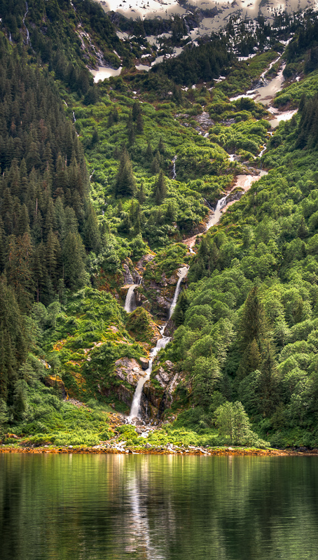
Anchored opposite this tall waterfall made for a pleasing sound all the while we were in Khutze

Later that afternoon, the white prawn boat (accompanied by the same dinghy we had seen that morning) came into the anchorage. Her name was The Connor J, from Nan., BC (Nanaimo?). She set a long string of prawn pots abeam us, and it was fun to watch the process.  That was probably the activity highlight of the day!

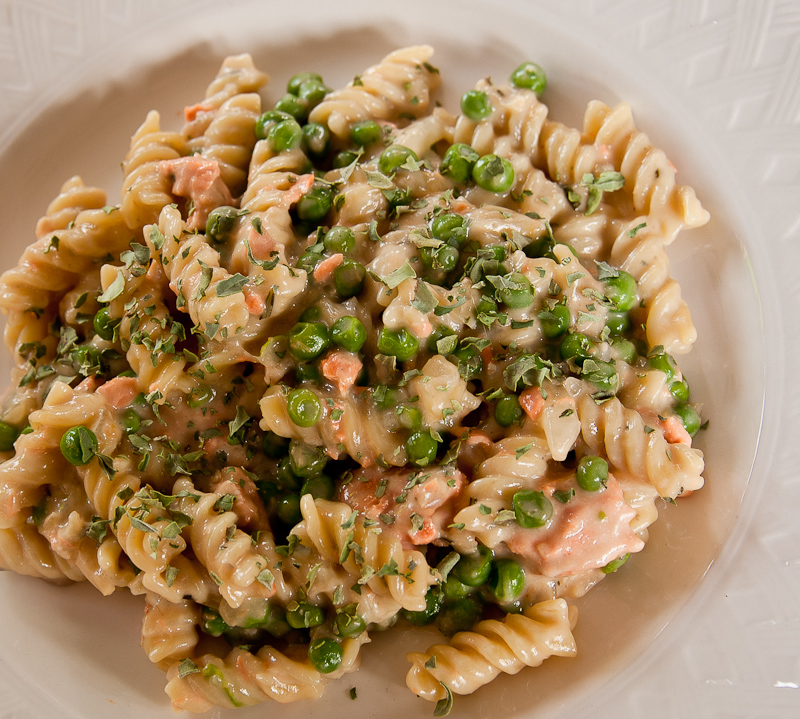
Dinner was salmon gorgonzola with fusilli and a few lemon cookies and two more extremely good episodes of The Good Wife, and then bed.  A peaceful night in a glorious spot.


Windy Bay to Horsefly Cove (Green Inlet)

As suspected, we awoke to light rain. It always seems to rain when I have to haul anchor! For the first time in a long time, we saw some targets on the AIS, tugs headed both north and south in Tolmie Channel. So there is boat traffic up here somewhere, hmm?

We had an uneventful trip through Hiekish Narrows, which was no big deal and easy to navigate.

Shortly afterwards, we turned into Green Inlet and headed in .6 miles to Horsefly Cove. The buzz on this anchorage was mixed, with some saying it was too deep and small to anchor comfortably without a stern tie. We decided to check it out for ourselves.

It’s a nice intimate spot, where you look back out at Green Inlet between a few islets. As we measured depths in our potential anchor spots and searched for the optimal place to drop the hook, we saw two gray wolves swim from one of the islets to the main body of land. We clearly surprised them – they froze when they saw us, and we watched each other for a long while. They eventually disappeared into the woods, never to reappear.

Windy Bay to Horsefly Cove-13_4_5_6-Edit-Edit

The view from Horsefly Cove

Finding that anchor spot was a challenge. It is deep, about 100 feet, and it’s not easy to back down enough to set the anchor without running into the shore. So we decided to stern tie, and thus the stern tie dance began. We actually set the anchor in about 70 feet, dropped 150’ of chain, and got close enough to do the stern tie without too many problems (and without having to leave the dinghy – no mountain goating for me this time). It was chilly and damp, and we were happy to get the boat secured. Not long after we were done, a sailing vessel exited the Inlet. We do not know where it had anchored, but it was clearly further down the inlet towards the rapids and lagoon.

Windy Bay to Horsefly Cove-4-Edit-3

I always wonder what forces placed this log here, standing at attention.

I wanted to dinghy down to see the rapids when they were flowing, despite the rain and wind, so I convinced Bob to take the excursion. It was a cold ride, and our eyes were definitely watering as we headed to the rapids. They were running hard, you could see all the boulders and from our perspective, it looked like a 2-3’ drop from the lagoon down to the inlet. These rapids are marked in the books as “unnavigable” – hard to say, but maybe you could portage the kayaks over the rocks off to the side and then paddle inside the lagoon? Too cold and wet to give it much thought.

20110609REM G2 uload thru 6_15_2011-15

The “entrance” to the lagoon is certainly imposing

On our way back, we stopped briefly at the small beach and creek across from Horsefly Cove, enjoying the sight of old pilings at low tide. We were happy to get back to the boat and warm up. As we were heading back to the boat, we did see one pleasure boat heading down the major channel outside of Green Inlet. It was the 2nd pleasure boat we’d seen in days.

Aboard, we decided to watch “Black Swan”, which was well acted but definitely creepy. Bob made meatloaf and we enjoyed it with mashed potato casserole. The Sat TV worked again to bring us the  Comedy Channel, which is how we get our news. Apparently the Weiner scandal will NOT go away.

As we went to bed, we heard loud scraping noises, which had us jumping up to see what was going on . The shift in the wind and current had moved us so that the anchor chain scraped rocks on the bottom. All looked good, so we went to sleep about 11:00.

The anchor alarm sounded about 12:30 am. Frankly, it’s most often a GPS anomaly, so I let Bob handle it. When he did not come back to bed right away, and I saw flashlight glare outside the cabin window, it was clear that I needed to get up as well.

The anchor alarm was just an anomaly. But the current had changed, and there was a tremendous amount of pressure on our stern line, and we had swung quite far to starboard, putting us closer to shore than we liked. Pulling up some anchor chain wasn’t  helpful, as the stern tie was so tight. It took a lot of elbow grease to loosen that tie enough to let the boat swing to a better spot. About an hour later, the current died down and the boat went back to its preferred lie, but we were both uncertain about how the rest of the night would go. So Bob slept on the couch in the saloon with the anchor circle image on our computer angled so he could see it. I think I got back to sleep about 3am. Oh yes…and it was raining.

Culpepper Lagoon to Windy Bay

Using Tom Bay for tide guidance, we figured we needed to be at the narrows by 7am.  I worried a bit about our calculations, because just as I was getting up (at 6am), the sailboat Imagine was hauling anchor and heading out. But we continued with our plan, hauled anchor at 6:38, and headed for the narrows.

Culpepper Lagoon to Windy Bay-10-Edit-Edit

Waterfall in Kynoch Inlet

When we arrived, the sailboat had already departed the lagoon, so we knew the currents were going to be fine for us. In fact, the narrows were virtually calm, and out we went. I was at the helm, as Bob tried to get the watermaker to work one last time. Very inconvenient up here in the back of beyond without a watermaker! This time, the unit would not even turn on. Clearly, some issues with the filters that we cannot address. Oh well, we enjoyed the sunshine as we headed out Kynoch Inlet. It was a short trip to Windy Bay, so we took a detour up Mussel Inlet to Oatswish Bay. This bay is marked as too deep for safe anchorage, but I wanted to check it out. Our route took us past the beautiful Lizette waterfall, and some seals on a rock by Thomas Island. The head of Oatswish was lovely, but as advertised, it would be a challenge and a half to find a tenable anchor spot.

Culpepper Lagoon to Windy Bay-93_4_5

Put on a show. Might make #1 waterfall so far on this trip. Not tall, but very interesting flows.

We turned back for Windy Bay. On the way, we ducked into Bolin Bay as a possible alternate, and didn’t like what we saw, so back to the original plan for Windy Bay. It is large and open, and we tucked in behind the islet where the water was calm and the sun was warm. Seals were hauled out on a drying rock next to the inlet, growling, and there was an unseen waterfall we could hear just off our anchor spot.

Culpepper Lagoon to Windy Bay-59-Edit-Edit

Bolin Bay would take a little time to find a place to anchor, but it might be worth it for the view.

It was a nice place to chill, and we spent a very lazy day reading and with Bob working on pictures. It wasn’t an anchorage that was calling for dinghy or kayak exploration, so we just relaxed.

Dinner was salmon gorgonzola and a nice Gerwurtztraminer, capped off with a few coconut cookies and the magic of satellite TV bringing us Jon Stewart, Stephen Colbert and South Park. Who could ask for more? We had a 6:30am departure to hit slack in Hiekish Narrows, so we didn’t stay up too late. Before bed, we noticed the air mass had changed and clouds were coming in. We went to bed all alone in Windy Bay.

Culpepper Lagoon to Windy Bay-133

That salmon shows up in another dinner


Culpepper Lagoon

I had planned for us to spend 2 nights in Culpepper Lagoon, and I was glad of it. The morning was sunny and calm, without those crazy winds of yesterday.  We were certainly slow to get going. I wanted to take the dinghy back to the narrows and go out again at low tide, to check out the head of Kynoch Inlet from the vantage point of the dinghy, and just tool around a bit. Brian had told us that he finds slack to be about an hour after Tom Bay, rather than 15-30 minutes before Bella Bella, which the guidebooks suggest. So we wanted to check out how close the Tom Bay calculations matched the actual conditions at the narrows.

20110606Culpepper Lagoon-82_3_4-Edit

Snow Ice still sits at the foot of this waterfall at the head of Kynoch Inlet. Even more amazing since it faces south.

The fact that we were so slow to get going was a bit of a problem, because by the time we got in the dinghy it was howling wind again and there were whitecaps in the Lagoon. It was going to be a wet ride up to the narrows! But, the narrows were nicely slack at about 1 hour after low tide at Tom Bay, so we now will use Brian’s method of calculating slack at Culpepper.

20110607Culpepper Lagoon-94-Edit

Karen capturing more memories during out dinghy ride

We exited the lagoon, tooled around the head of the inlet near the mudflats, and then headed over to Riot Creek (back inside the Lagoon) where an old cabin used to be located. There were no signs left of the cabin, but the creek was beautiful and the current was riotous. It hit the water of the lagoon and made some choppy waves, but as soon as we headed back to the boat, there was no more wind and chop. We passed by ‘seal rock’ and saw the seals basking in the sun again.

20110607Culpepper Lagoon-200_1_2_3-Edit

Riot Creek earned its name

20110607Culpepper Lagoon-218-Edit

Rock + Sun = Seal haul out

We agreed that we needed to go kayaking when the tide was nearing the high, so that we could go across the mudflats and up Lard Creek as far as possible. There was time to kill, so Bob worked on pictures while I sat upstairs and read. Apparently the hummingbird from yesterday came back into the boat through an open window, and Bob had to don his oven mitts and rescue it again, freeing it from captivity inside of Alaskan Dream. It must be attracted to the red kayaks.

We were anxious to kayak, so we left a bit early, say at mid-tide, rather than nearly high tide. We crossed the mudflats with no issue and soon were paddling up the creek with the stony bottom clearly visible in the clear water. We went a good ways up, and had to battle the creek’s current. We were finally blocked from proceeding further by rapids over a downed tree. We needed at least another foot of water to move ahead, and so we turned around.

20110607Culpepper Lagoon Paddle-19-Edit

Warm sun, clear river, snow capped mountains in the background. Pretty great!

The ride out was great, due to the favorable current at our backs. We saw bear prints in the muddy banks of the river, but none of the animals themselves. The creek banks were full of lavender fireweed, and we enjoyed some photo ops in the sun.

IMG_0602-Edit

We think the name of the purple flowers in the background is lavender fireweed.

IMG_0606

Paddling back to Alaskan Dream

IMG_0612-Edit-Edit

It's a short sleeved day. A first for this trip!

As we headed back to the boat, a Sailboat appeared and the wind started to pick up. The sailboat was apparently single-handed by a man – he set his anchor twice, was satisfied the 2nd time, dropped his kayak overboard and immediately went for a long paddle. The name of his boat was Imagine.

We had my favorite meal – Bob’s meatloaf – with drop biscuits and mashed sweet potatoes for dinner. We turned in early, because we had an early departure (6:30am) to catch high slack at the narrows to exit the lagoon.

James Bay to Culpepper Lagoon

We were up early again, so that we could catch low slack at Culpepper Lagoon (10ish). We decided to have breakfast enroute. As Bob was cooking and I was helming, I suddenly saw the Mother Goose fleet on AIS, about 5 miles ahead of us. We had suspected we would run into them as they departed Culpepper, but they were already out of Kynoch Inlet and headed up to Mathieson Narrows.

Bob hailed Brian on Deception and we got the skinny on good anchor spots and were also told that the Lagoon was devoid of boats at the time. That sounded good to us. As we headed up Kynoch Inlet, we saw lots of waterfalls and high mountains with snowy peaks along the way. It was really breathtaking. When we reached the head of the Inlet, we took a look at the Narrows and could easily tell from the white water flowing out that we were early.

James Bay to Cu;pepper Lagoon-79_80_81

Culpepper Lagoon rapids still running strong

We kind of figured that, because we were about an hour ahead of our calculated slack. So we enjoyed the scenery at the very attractive valley (with mudflats) at the head of Kynoch and patiently waited for slack. Bob maneuvered the boat in all directions, watching the birdlife on the flats and the seals, while I read a while. About 10:45 the narrows looked pretty good, and that was after when the guidebooks said slack would occur, so we decided to go for it.

Entering Culpepper Lagoon from Robert Minkus on Vimeo.

That entrance sure looks rocky and narrow at low water. As we got into the approach, we found 4kts of adverse current in the narrowest part, and Bob had to add power to the engines to keep good forward speed.We saw 12.7’ of water on a 2 foot low tide at Bella Bella. That was plenty of water for us, but definitely had our attention.

Once through, we toured the lagoon, passing a rock full of seals basking in the sun. We then got to the head, and were thankful we had arrived at low tide. You could see the mudflats, which was helpful, but it was still time consuming to find the right spot to anchor. We made a very careful set of anchor circles, marking the depth along the way, to make sure we could anchor safely and let out enough scope to ride any winds without swinging onto the flats. The anchor dance took about an hour. Once we set the anchor…the peaceful lagoon became a wind tunnel. Bob took a nap, and I sat glued to the computer image of the anchor “circle”, making sure we were really holding and not dragging toward those flats. Despite the wind, we held firm, and we had a relaxing afternoon. A hummingbird decided to come aboard, and Bob had to put on the oven mitts and gently capture it in his hands, then toss it out the window to free it from confinement in the boat.

The visual picture of the anchorage was totally different by high tide. All the mud flats were completely covered over and it seemed like we were anchored so far out from the grassy shore! We were again so glad we had come at low tide our first time into the lagoon. We remained all alone, though we did see a small boat come in, set a few prawn pots, and then leave again.

James Bay to Cu;pepper Lagoon-336_7_8-Edit_FLOOD2

The view at high tide

James Bay to Cu;pepper Lagoon-336_7_8-Edit_EBB2

The same view at low tide with the mud flats revealed (when we anchored)

Dinner was excellent grilled salmon with orange marmalade glaze, jasmine rice with craisins and pine nuts, and Bob’s homemade drop biscuits. YUM! About 9pm, the winds finally died down. We watched the movie “The Fighter” (we both didn’t like it) and hit the sack about 11pm.

James Bay to Cu;pepper Lagoon-359

The wild salmon you find out here is nothing like what you get anywhere else, even if you purchase it in a grocery store as I did.